Members
altPressed :Boolean
Type:
- Boolean
- Source:
(constant) animSong :String
Type:
- String
- Source:
(constant) animate
Define an animation loop.
Step 0.5° ⇒ 60 fps = 30°/s ⇒ 360° in 12s(constant) aspect :Number
Type:
- Number
- Source:
(constant) audio :Audio
Type:
- Audio
- Source:
axis :String
Type:
- String
- Source:
axisBuffer :WebGLBuffer
Type:
- WebGLBuffer
- Source:
axisColorBuffer :WebGLBuffer
Type:
- WebGLBuffer
- Source:
(constant) axisColors :Float32Array
Type:
- Float32Array
- Source:
(constant) axisVertices :Float32Array
Type:
- Float32Array
- Source:
(constant) canvas :HTMLCanvasElement
Canvas element and its tooltip.
Canvas is used for drawing the globe and its tooltip is used for displaying the GCS coordinates (longitude and latitude) on the globe when pointer is moved upon.
Canvas is a bitmap element that can be used to draw graphics on the fly via scripting (usually JavaScript). It is a part of the HTML5 specification and is supported by all modern browsers.
Tooltip is a small pop-up box that appears when the user hovers over an element. It is used to provide additional information about the element, such as its coordinates.
Both canvas and tooltip are used to provide a better user experience by allowing the user to interact with the globe and see its coordinates.
Type:
- HTMLCanvasElement
- Source:
(constant) canvastip :HTMLElement
Tooltip element for displaying GCS coordinates on the globe.
Tooltip is a small pop-up box that appears when the user hovers over an element. It is used to provide additional information about the element, such as its coordinates.
Tooltip is used to provide a better user experience by allowing the user to interact with the globe and see its coordinates.
Type:
- HTMLElement
- Source:
(constant) cities :Object
Type:
- Object
Properties:
| Name | Type | Description |
|---|---|---|
byLongitude |
Array.<String> | city names ordered by longitude. |
byDate |
Array.<String> | city names ordered by date. |
current |
Array.<String> | current city names. |
previous |
String | previous city name. |
timeline |
Array.<Number> | list of city years. |
longitude |
Array.<Number> | list of city longitudes. |
country |
Array.<String> | city names in the selected country. |
nameToDate |
Array.<{String, Number}> | map of city names to dates. |
nameToLongitude |
Array.<{String, Number}> | map of city names to longitudes. |
- Source:
colorBuffer :WebGLBuffer
Type:
- WebGLBuffer
- Source:
colorShader :WebGLShader
Type:
- WebGLShader
- Source:
(constant) colorTable :Object.<String, (Array.<Number>|String)>
-
------- lines -----------------
- loxodrome: [1,0,1,1] // magenta
- meridian: [1,0,0,1] // red
- great_circle: [0,1,1,1] // cyan
- normal: [1,1,0,1] // yellow ------- points --------------
- unknown: [0,0,1] // blue
- null: [0,0,0], // black
- poiAD: [1,0,0] // red
- poiBC: [1,1,0] // yellow ------- HTML5 -------------
- rhumb: "magenta"
- mer: "red"
- gc: "cyan"
- un: "blue"
- nu: "black"
- ad: "red"
- bc: "yellow"
Type:
- Object.<String, (Array.<Number>|String)>
- Source:
controlPressed :Boolean
Type:
- Boolean
- Source:
country :String
Type:
- String
- Source:
culling :Boolean
Type:
- Boolean
- Source:
- See:
currentLocation :String
Type:
- String
- Source:
(constant) currentMeridian :GCS
Type:
- Source:
cursorPosition :Object.<{x:Number, y:Number}>
Type:
- Object.<{x:Number, y:Number}>
- Source:
(constant) dr :Number
Type:
- Number
- Source:
(constant) earthMajorAxis :Number
Type:
- Number
- Source:
(constant) earthRadius :Number
Radius of the earth in kilometers.
- Mean-radius: 6,371,007.1809 m (radius of sphere of equal surface area)
- Semi-major axis (a): 6,378,137 m (equatorial radius)
- Semi-minor axis (b): 6,356,752.3142 m (polar radius)
- Flattening (f): 1 / 298.257223563
- First eccentricity (e): 0.0818191908426
- First eccentricity squared (e²): 0.00669437999014
Type:
- Number
- Source:
(constant) ecc :Number
Type:
- Number
- Source:
(constant) element :Object
Type:
- Object
Properties:
| Name | Type | Description |
|---|---|---|
mesh |
HTMLInputElement | checkbox |
axes |
HTMLInputElement | radio |
equator |
HTMLInputElement | checkbox |
hws |
HTMLInputElement | checkbox |
fix_uv |
HTMLInputElement | checkbox |
merc |
HTMLInputElement | checkbox |
cull |
HTMLInputElement | checkbox |
texture |
HTMLInputElement | checkbox |
textures |
HTMLSelectElement | select |
models |
HTMLSelectElement | select |
textimg |
HTMLImageElement | img |
tooltip |
HTMLInputElement | checkbox |
tip |
HTMLInputElement | checkbox |
php |
HTMLInputElement | checkbox |
print |
HTMLInputElement | button |
screenshot |
HTMLInputElement | checkbox |
closest |
HTMLButtonElement | button |
animation |
HTMLButtonElement | button |
byDate |
HTMLInputElement | checkbox |
locations |
HTMLInputElement | checkbox |
timeline |
HTMLInputElement | range |
lblTimeline |
HTMLLabelElement | label |
steplist |
HTMLDataListElement | list |
country |
HTMLSelectElement | select |
loxodrome |
HTMLInputElement | checkbox |
canvasimg |
HTMLCanvasElement | canvas |
latitude |
HTMLInputElement | input |
longitude |
HTMLInputElement | input |
locInfo |
HTMLDivElement | div |
search |
HTMLInputElement | div |
city |
HTMLSelectElement | select |
- Source:
- See:
(constant) eye :vec3
Type:
- Source:
fixuv :Boolean
Type:
- Boolean
- Source:
- See:
(constant) forwardVector :vec3
Current forward vector (0,0,1) or (-90°,0°) in GCS coordinates, which corresponds to the z-axis in the intrinsic frame and where the phong highlight position is set on the globe.
Each time the model is rotated towards the camera, this vector is updated to its new position in the extrinsic frame.Type:
- Source:
gl :WebGL2RenderingContext
Type:
- WebGL2RenderingContext
- Source:
globeRadius :Number
Type:
- Number
- Source:
gpsCoordinates :Object.<location:String, attributes:Object>
Type:
- Object.<location:String, attributes:Object>
Properties:
| Name | Type | Description | |||||||||||||||
|---|---|---|---|---|---|---|---|---|---|---|---|---|---|---|---|---|---|
location |
String | name of the site, e.g., "Paris". | |||||||||||||||
attributes |
Object |
Properties
|
- Source:
image :HTMLImageElement
Type:
- HTMLImageElement
- Source:
- See:
(constant) imageFilename :Array.<String>
Type:
- Array.<String>
- Source:
indexBuffer :WebGLBuffer
Type:
- WebGLBuffer
- Source:
(constant) isIOS :Boolean
Type:
- Boolean
- Source:
isMap :Boolean
Type:
- Boolean
- Source:
(constant) isSafari :Boolean
Type:
- Boolean
- Source:
(constant) lightPosition :Array.<Number>
Light Position.
Phong illumination model will highlight the projection of this position on the current model.In the case of a sphere, it will trace the equator, if no other rotation is applied by the user.
Type:
- Array.<Number>
- Source:
(constant) lightPropElements :Object.<String:Float32Array>
Light properties.
Ambient, diffuse and specular.Remember this is column major.
Type:
- Object.<String:Float32Array>
- Source:
lightingShader :WebGLShader
Type:
- WebGLShader
- Source:
lineBuffer :WebGLBuffer
Type:
- WebGLBuffer
- Source:
(constant) lineWidth :Number
Type:
- Number
- Source:
lines :Float32Array
Type:
- Float32Array
- Source:
locationsBuffer :WebGLBuffer
Type:
- WebGLBuffer
- Source:
loxodrome :Boolean
Type:
- Boolean
- Source:
mat3 :glMatrix.mat3
Type:
- glMatrix.mat3
- Source:
- See:
mat4 :glMatrix.mat4
Type:
- glMatrix.mat4
- Source:
- See:
(constant) matPropElements :Object.<String:Float32Array>
Material properties.
Ambient, diffuse and specular.Remember this is column major.
Type:
- Object.<String:Float32Array>
(constant) maxLatitude :Number
Maximum latitude for Mercator projection.
- tan-1(sinh(π)) in degrees
Type:
- Number
- Source:
maxSubdivisions :Number
Type:
- Number
- Source:
mercator :Boolean
Type:
- Boolean
- Source:
- See:
mercatorVertices :Array.<Object>
Type:
- Array.<Object>
- Source:
meridianBuffer :WebGLBuffer
Type:
- WebGLBuffer
- Source:
(constant) mobile :Boolean
Type:
- Boolean
- Source:
(constant) modelM :mat4
Model matrix for rotating the model towards the camera around the forward vector.
Used only for displaying a location at the center of the globe.Type:
- Source:
- See:
modelMatrix :mat4
Model matrix.
Transforms from model coordinates to world coordinates.
Used only when rotating the model around the coordinate axes (intrinsic or extrinsic rotations) or along a meridian.A rotation along a parallel corresponds to an intrinsic rotation around the y-axis.
Type:
- Source:
- See:
(constant) monitorTable :Array.<Array.<Number>>
- 96 - standard CSS pixel density (1024X768) 13.3" (CRT)
- 96.42 - Sansung Syncmaster (1280X1024) 17" (HD)
- 117.5 - Dell U2515H, (2560x1440) 25" (QHD/2K)
- 127.68 - MacBook air 2017, (1440x900) 13.3"
- 141.21 - Inspiron 15 5848, (1920x1080) 15.6" (Full HD)
- 141.21 - LG Flatron E2350, (1920x1080) 23" (Full HD)
- 163.18 - Dell Plus (3840x2160) 27" (4K UHD)
- 326 - iPhone SE, (320x568) 4" DPR=2 (retina)
- 401 - iPhone 7+, (414x736) 5.5" DPR=3 (retina)
- 326 - iPhone 8, (375x667) 4.7" DPR=2 (retina)
- 326 - iPhone 11, (414x896) 6.1" DPR=2 (retina)
- 460 - iPhone 13, (390x844) 6.1" DPR=3 (retina)
- 326 - iPad mini 5, (768x1024) 7.9" DPR=2 (retina)
Type:
- Array.<Array.<Number>>
mscale :Number
Type:
- Number
- Source:
noTexture :Boolean
Type:
- Boolean
- Source:
normal :Float32Array
Type:
- Float32Array
- Source:
normalBuffer :WebGLBuffer
Type:
- WebGLBuffer
- Source:
numSubdivisions :Number
Type:
- Number
- Source:
parallelBuffer :WebGLBuffer
Type:
- WebGLBuffer
- Source:
(constant) phongHighlight :vec2
Type:
- Source:
(constant) pixelRatio :Number
Device Pixel Ratio (DPR).
The ratio of physical pixels to CSS pixels, e.g.:- 1.0 for standard displays
- 2.0 for retina screens
Type:
- Number
- Source:
(constant) pointRadius :Number
Type:
- Number
- Source:
(constant) pointSize :Number
Type:
- Number
- Source:
previousLocation :gpsCoordinates
Type:
- Source:
(constant) projection :mat4
Type:
- Source:
(constant) readFileNames :Promise.<Array.<String>>
Promise for returning an array with all file names in directory './textures'.
Since php runs on the server, and javascript on the browser, a php script is invoked asynchronously via ajax, because Javascript doesn't have access to the filesystem.
The JavaScript Fetch API provides a modern, promise-based interface for making network requests, such as fetching data from an API. It is designed to replace older methods like XMLHttpRequest and offers a more streamlined way to handle asynchronous operations.
The Response object provides methods to parse the response body in various formats, such as json(), text(), blob(), arrayBuffer(), and formData().Type:
- Promise.<Array.<String>>
- Source:
- See:
(constant) rotMatrix :Object
Rotation matrix for the three axes.
The rotation matrices are created at compile (loading) time, so that they can be reused in each frame without recalculating them. The rotation matrices are used to rotate the model around the x, y, or z-axis, depending on the axis chosen. The rotation is done by multiplying the model matrix with the rotation matrix, either on the left (extrinsic rotation) or on the right (intrinsic rotation).Type:
- Object
Properties:
| Name | Type | Description |
|---|---|---|
x |
mat4 | rotation matrix around the x-axis. |
y |
mat4 | rotation matrix around the y-axis. |
z |
mat4 | rotation matrix around the z-axis. |
- Source:
(constant) rotationMatrix :mat4
Rotation matrix for rotating the model towards the camera.
Type:
- Source:
rotator :SimpleRotator
Type:
- Source:
searchPredicate :function
Type:
- function
- Source:
searchResult :Array.<String>
Type:
- Array.<String>
- Source:
(constant) selector :Object
Type:
- Object
Properties:
| Name | Type | Description |
|---|---|---|
lines |
Boolean | mesh and normals. |
texture |
Boolean | lines x texture. |
axes |
Boolean | coordinate axes. |
paused |
Boolean | Arcball x rotation. |
intrinsic |
Boolean | rotation around global x local axes. |
equator |
Boolean | parallel and meridian of the current location. |
hws |
Boolean | model's triangulation algorithm source: three.js x hws. |
tooltip |
Boolean | location information. |
cities |
Boolean | sequential location traversal order. |
locations |
Boolean | location points. |
- Source:
(constant) shininess :Array.<Number>
Specular term exponent used in the Phong reflection model.
One entry for each material property.Type:
- Array.<Number>
- Source:
(constant) sphereRadius :Number
Radius of the sphere.
Subdivision sphere is a unit sphere and therefore the current globe radius must be restored to this value.Type:
- Number
- Source:
(constant) teapotModel :modelData
Type:
- Source:
texCoordBuffer :WebGLBuffer
Type:
- WebGLBuffer
- Source:
textureCnt :Number
Type:
- Number
- Source:
textureHandle :WebGLTexture
Type:
- WebGLTexture
- Source:
- See:
theModel :modelData
Type:
- Source:
unit :String
Type:
- String
- Source:
vec2 :glMatrix.vec2
Type:
- glMatrix.vec2
- Source:
vec3 :glMatrix.vec3
Type:
- glMatrix.vec3
- Source:
vec4 :glMatrix.vec4
Type:
- glMatrix.vec4
- Source:
vertexBuffer :WebGLBuffer
Type:
- WebGLBuffer
- Source:
vertexNormalBuffer :WebGLBuffer
Type:
- WebGLBuffer
- Source:
(constant) viewMatrix :mat4
Type:
- Source:
- See:
yNorth :Boolean
Type:
- Boolean
- Source:
zoomPressed :Boolean
Type:
- Boolean
- Source:
Methods
UV2Conical(uv, mercopt) → {Array.<{Number, Number, Number, Number}>}
Parameters:
| Name | Type | Attributes | Default | Description |
|---|---|---|---|---|
uv |
Object.<{s: Number, t:Number}> | ∈ [0,1]. | ||
merc |
Boolean |
<optional> |
mercator | apply mercator transformation if true. |
- Source:
Returns:
- Type
- Array.<{Number, Number, Number, Number}>
UV2Cylindrical(uv, mercopt) → {Array.<{Number, Number, Number}>}
Parameters:
| Name | Type | Attributes | Default | Description |
|---|---|---|---|---|
uv |
Object.<{s: Number, t:Number}> | ∈ [0,1]. | ||
merc |
Boolean |
<optional> |
mercator | apply mercator transformation if true. |
- Source:
Returns:
- Type
- Array.<{Number, Number, Number}>
UV2Spherical(uv) → {Array.<{Number, Number}>}
Parameters:
| Name | Type | Description |
|---|---|---|
uv |
Object.<{s: Number, t:Number}> | ∈ [0,1]. |
- Source:
Returns:
- Type
- Array.<{Number, Number}>
addGroup(group)
Parameters:
| Name | Type | Description |
|---|---|---|
group |
String | description. |
- Source:
- See:
-
addListeners()
Appends event listeners to HTML elements.
Also appends event listeners to the rot and mode input radio buttons.
- Source:
- See:
addSymbolInCountry(c, str)
Adds an emoji symbol to all countries in a given array.
If the symbol is empty, the first symbol of all countries is removed.Parameters:
| Name | Type | Description |
|---|---|---|
c |
Array.<String> | country array. |
str |
String | symbol. |
- Source:
antimeridianCrossing(deltaLongitude, degrees) → {Number}
Handle longitudinal crossing of anti-meridian for getting the shortest arc.
return Math.abs(deltaLongitude) > Math.PI ? 2 * Math.PI - Math.abs(deltaLongitude) : Math.abs(deltaLongitude);Parameters:
| Name | Type | Default | Description |
|---|---|---|---|
deltaLongitude |
Number | difference between two longitudes in radians. | |
degrees |
Boolean | false | whether the input is in degrees or radians (default: false). |
- Source:
- See:
-

Conjugate (explementary) angles.
Returns:
- Type
- Number
bearingAngle(gcs1, gcs2) → {Number}
Calculate the bearing angle between two GCS coordinates.
A bearing (or azimuth) angle is a horizontal, clockwise angle measured from North (000°) to determine direction in navigation and surveying. It is represented using three figures (e.g., 045° for Northeast) in the range [000°, 360°).
Formula:   Δψ = ln( tan(π/4 + φ2/2) / tan(π/4 + φ1/2) )
           θ = atan2(Δλ, Δψ)

where:     φ is geodetic latitude, ψ is isometric latitude, λ is longitude,
           Δλ is taking shortest route (<180°), R is the earth’s radius,
           ln is natural log

note:  if the two locations are on the same parallel (Δφ = 0),
       the bearing angle is either 90° or 270°
       atan2(±y, 0) is ±π/2, which corresponds to -90° or 90° in degrees.
       atan2(0,0) is 0, which corresponds to 0° in degrees.
Parameters:
| Name | Type | Description |
|---|---|---|
gcs1 |
GCS | first pair of gcs coordinates. |
gcs2 |
GCS | second pair of gcs coordinates. |
- Source:
- See:
Returns:
- Type
- Number
bearingAngleAndDistance(gcs1, gcs2, Ropt) → {Object.<{bearing: Number, distance: Number}>}
Returns the bearing angle (azimuth) and distance between two points on a loxodrome (rhumb line).
- Δlat (Difference of Latitude): the north-south distance between the departure and destination points, measured in minutes of arc or nautical miles (1' = 1 NM).
- Bearing (θ): the constant angle (course) between the meridian and the path of the vessel.
- Departure (Δlat * tan(bearing)): the east-west distance in nautical miles, which changes depending on the latitude (narrowing towards the poles).
- Distance (D): the length of the loxodrome, calculated as:
- dLat = lat2 - lat1, in radians
- dLon = lon2 - lon1, in radians
- nautical miles = minutes of arc along a meridian (1' = 1 NM)
- sin(90-bearing) = cos(bearing)
- dLat = nm * sin(90-bearing) = nm * cos(bearing)
- D = R * |dLat| * sec (bearing), if dLat != 0
- D = R * |dLon| * cos (lat1), if dLat == 0
Parameters:
| Name | Type | Attributes | Default | Description |
|---|---|---|---|---|
gcs1 |
GCS | latitude and longitude of the first point in degrees. | ||
gcs2 |
GCS | latitude and longitude of the second point in degrees. | ||
R |
number |
<optional> |
earthRadius | radius of the Earth in kilometers (default: 6371 km). |
- Source:
- See:
-
- Mercator sailings
- Notes on Loxodrome Calculations
- The loxodrome and two projections of the sphere
- Loxodrome Sailing
- Course angle and the distance between the two points on loxodrome
- Calculate distance, bearing and more between Latitude/Longitude points
- New Definitions of the Isometric Latitude and the Mercator Projection
Returns:
- Type
- Object.<{bearing: Number, distance: Number}>
bearingAngleAndDistanceCyl(gcs1, gcs2, Ropt) → {Object.<{bearing: Number, distance: Number}>}
Calculates the bearing angle (course) and distance between two points on a cylinder using the loxodrome path.
Parameters:
| Name | Type | Attributes | Default | Description |
|---|---|---|---|---|
gcs1 |
GCS | latitude and longitude of the first point in degrees. | ||
gcs2 |
GCS | latitude and longitude of the second point in degrees. | ||
R |
Number |
<optional> |
earthRadius | radius of the Earth in kilometers (default: 6371 km). |
- Source:
Returns:
- Type
- Object.<{bearing: Number, distance: Number}>
binarySearch(arr, target) → {Number}
Performs a binary search on a sorted array to find the index of a target in O(log(n)).
Parameters:
| Name | Type | Description |
|---|---|---|
arr |
Array | the sorted array to search. |
target |
String | Number | the value to search for. |
- Source:
- See:
Returns:
- Type
- Number
calculateLoxodromeDistance(lat1, lon1, lat2, lon2, Ropt) → {number}
Calculates loxodromic (rhumb line) distance between two points.
Formula:   Δψ = ln( tan(π/4 + φ2/2) / tan(π/4 + φ1/2) )
           q = Δφ / Δψ (or cosφ for E-W line)
           d = √(Δφ² + q²⋅Δλ²) ⋅ R 	(Pythagoras)

where:     φ is geodetic latitude, ψ is isometric latitude, λ is longitude,
           Δλ is taking shortest route (<180°), R is the earth’s radius,
           ln is natural log
Parameters:
| Name | Type | Attributes | Default | Description |
|---|---|---|---|---|
lat1 |
number | latitude of first point in degrees. | ||
lon1 |
number | longitude of first point in degrees. | ||
lat2 |
number | latitude of second point in degrees. | ||
lon2 |
number | longitude of second point in degrees. | ||
R |
number |
<optional> |
earthRadius | radius of the Earth in kilometers (default: 6371 km). |
- Source:
- See:
-
- Mercator sailings
- Notes on Loxodrome Calculations
- The loxodrome and two projections of the sphere
- Loxodrome Sailing
- Course angle and the distance between the two points on loxodrome
- Calculate distance, bearing and more between Latitude/Longitude points
- New Definitions of the Isometric Latitude and the Mercator Projection
Returns:
- Type
- number
calculateLoxodromeDistanceCyl(lat1, lon1, lat2, lon2, Ropt) → {number}
Calculates loxodromic (rhumb line) distance between two points on cylinder.
Loxodromes appear as straight lines on a Mercator chart, but their length on the map is generally larger than their actual shorter length on the spherical surface. Calculations show that a loxodrome spanning latitudes (e.g., 55°S to 55°N) can measure significantly more on the map compared to its actual length on the sphere.
For example, the length of the loxodrome between Syracuse, New York and Moscow with the assumed Earth’s radius is 8,283.2 km. The distance between Syracuse and Moscow on a map drawn in the Mercator projection is 12,820.7 km. This is the length of the loxodrome image on the map, which is significantly different from the length of the loxodrome on the sphere.
   Syracuse, NY (lat1 = 43°00'00" N, lon1 = 76°00'00" W)  (43.046944, -76.144444)
   Moscow       (lat2 = 55°45'00" N, lon2 = 37°37'00" E)  (55.751244, 37.618423)
   R = 6370 km                                             R = 6371 km
   On chart = 12,820.7 km                                  On chart = 12,838 km
   On globe = 8,283.2 km                                   On globe = 8,290 km
- Δlat (Difference of Latitude): the north-south distance between the departure and destination points,
measured in minutes of arc or nautical miles (1' = 1 NM). - Δlon (Difference of Longitude): the east-west distance between the departure and destination points.
- Distance (D): the length of the loxodrome, calculated as:
- dLat = lat2 - lat1, in radians
- dLon = lon2 - lon1, in radians
- D = √ (R * dLat) 2 + (R * dLon) 2 ---------------- Area ------------------
- Sphere = 4πR²
- Equator = 2πR
- Chart Equirect = 2πR x πR = 2π²R²
- Chart Mercator = 2πR x 2πR = 4π²R²
- Cylinder = 2πRH = 2πR x πR = 2π²R² (2x1 aspect) ----------- Area x Length -------------
- Area(C) = Area(CE) > Area(S)
- Loxodrome(C) = Loxodrome(CE) ≥ Loxodrome(S)
Parameters:
| Name | Type | Attributes | Default | Description |
|---|---|---|---|---|
lat1 |
number | latitude of first point in degrees. | ||
lon1 |
number | longitude of first point in degrees. | ||
lat2 |
number | latitude of second point in degrees. | ||
lon2 |
number | longitude of second point in degrees. | ||
R |
number |
<optional> |
earthRadius | radius of the Earth in kilometers (default: 6371 km). |
- Source:
- See:
-
- Finding the Geodesic on a Cylinder
- A New Derivation of the Formula for the Length of a Loxodrome Arc on a Sphere Using Cylindrical Projections

Archimedes: Area(S) = Area(C) = 2π r x 2r = 4π r² 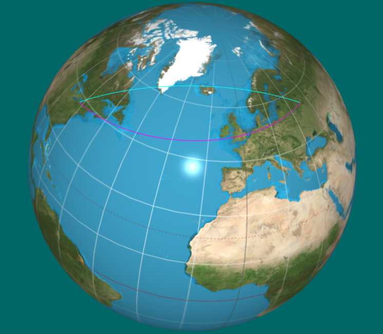
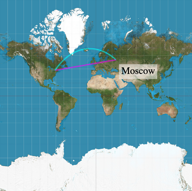
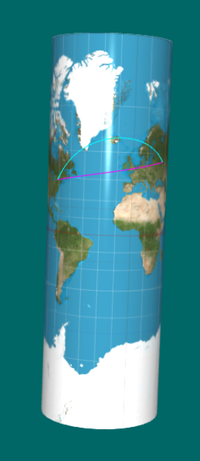
Syracuse - Moscow (Azimuth: 80.19°)
Returns:
- Type
- number
calculateLoxodromeDistanceWGS84(lat1, lon1, lat2, lon2, Ropt) → {number}
Calculates the total distance along a rhumb line (loxodrome) between two points on an ellipsoid by using the WGS84 model parameters for precision.
Switching from a WGS84 ellipsoid model to a simple sphere changes calculated surface distances by up to 0.5% (~56 parts per 10,000), creating regional overestimations or underestimations depending on the azimuth and latitude range.
   // London to New York
   const [lat1, lon1] = [51.5074, -0.1278]; // London
   const [lat2, lon2] = [40.7128, -74.006]; // New York

   const distance = calculateLoxodromeDistanceWGS84(lat1, lon1, lat2, lon2);
   console.log(`Loxodromic distance: ${distance.toFixed(1)} km`);

   ----------------------------------------
   Loxodromic course: 258.08°
   Isometric Latitude: -0.272161435475466
   Loxodromic distance: 5809.8 km
Parameters:
| Name | Type | Attributes | Default | Description |
|---|---|---|---|---|
lat1 |
number | latitude of starting point in degrees. | ||
lon1 |
number | longitude of starting point in degrees. | ||
lat2 |
number | latitude of destination point in degrees. | ||
lon2 |
number | longitude of destination point in degrees. | ||
R |
number |
<optional> |
earthMajorAxis | earth semi-major axis in kilometers. |
- Source:
- See:
Returns:
- Type
- number
calculatePPI(widthPixels, heightPixels, diagonalInches) → {Number}
Returns the monitor pixel density given its screen resolution and diagonal length.
Parameters:
| Name | Type | Description |
|---|---|---|
widthPixels |
Number | horizontal resolution. |
heightPixels |
Number | vertical resolution. |
diagonalInches |
Number | diagonal length of the screen. |
- Source:
Returns:
- Type
- Number
chartBackground(canvasopt)
Draws the texture image on a canvas as a background.
This allows the texture to be used as a background for the WebGL rendering.Parameters:
| Name | Type | Attributes | Default | Description |
|---|---|---|---|---|
canvas |
HTMLCanvasElement |
<optional> |
element.canvasimg | the canvas element to draw on. |
- Source:
- See:
checkForMapTexture(filename) → {Boolean}
Parameters:
| Name | Type | Description |
|---|---|---|
filename |
String | texture fine name. |
- Source:
Returns:
- Type
- Boolean
clamp(value, min, max) → {Number}
Parameters:
| Name | Type | Description |
|---|---|---|
value |
Number | value to be clamped. |
min |
Number | minimum value. |
max |
Number | maximum value. |
- Source:
Returns:
- Type
- Number
cleanLocation(location) → {String}
Parameters:
| Name | Type | Description |
|---|---|---|
location |
String | name of the location. |
- Source:
Returns:
- Type
- String
closestSite(position) → {Object.<site:String, distance:Number>}
Returns the closest site to the given GCS position (latitude, longitude).
An exaustive search is performed by iterating over all the sites and calculating the distance to each site using the haversine formula. The site with the smallest distance is returned as the closest site.Note that the "Unknown" site is skipped in the search.
 let minDist = Infinity;
 for (const site of cities.current) {
   if (site !== "Unknown") {
     // Skip Unknown elements
     const distance = haversine(position, gpsCoordinates[site]).m;
     if (distance < minDist) {
       closest = site;
       minDist = distance;
     }
   }
 }
 return minDist;
Alternatively, the closest site could be found using the reduce method of arrays.
Parameters:
| Name | Type | Description |
|---|---|---|
position |
GCS | GCS coordinates. |
Returns:
- Type
- Object.<site:String, distance:Number>
coterminalAngle(n, degreesopt) → {Number}
Convert an angle to its coterminal angle in the range [0°, 360°).
Negative angles and angles greater than a full revolution are more awkward to work with than those in the range of 0° to 360°, or 0 to 2π. It would be convenient to replace those out-of-range angles with a corresponding angle within the range of a single revolution.Parameters:
| Name | Type | Attributes | Default | Description |
|---|---|---|---|---|
n |
Number | angle in degrees. | ||
degrees |
Boolean |
<optional> |
true | whether the angle is in degrees (true) or radians (false). |
- Source:
- See:
Returns:
- Type
- Number
createEvent(key) → {KeyboardEvent}
Parameters:
| Name | Type | Description |
|---|---|---|
key |
String | char code. |
- Source:
Returns:
- Type
- KeyboardEvent
createModel(model) → {modelData|module:polyhedron~polyData}
Sets up all buffers for the given (triangulated) model (shape).
Uses the webgl vertex buffer, normal buffer, texture buffer and index buffer, created in startForReal.Then, binds each one of them as an array buffer and copies the corresponding shape array data to them.
Also, the Euler characteristic for the model is:
- χ = 2 − 2g − b
The number of triangles must be even for a valid triangulation of the sphere:
- V - E + T = 2 (sphere)
- V - E + T = 1 (trefoil knot)
- V - E + T = 0 (torus)
Parameters:
| Name | Type | Description |
|---|---|---|
model |
Object | model descriptor. |
Properties:
| Name | Type | Default | Description |
|---|---|---|---|
model.shape |
modelData | a BREP model given as an IFS. | |
model.name |
String | "" | model name. |
model.chi |
Number | null | 2 | model Euler Characteristic. |
model.poly |
Number | 0 | initial polyhedron for subdivision: 0 - dodecahedron, 1 - icosahedron, 2 - octahedron, 3 - tetrahedron. |
model.fix_uv |
Boolean | false | whether to change uv texture coordinates. |
- Source:
- See:
Returns:
createProgram(gl, vshader, fshader) → {WebGLProgram}
Parameters:
| Name | Type | Description |
|---|---|---|
gl |
WebGLRenderingContext | GL context. |
vshader |
String | a vertex shader program. |
fshader |
String | a fragment shader program. |
Returns:
- Type
- WebGLProgram
cube(side) → {modelData}
Create a model of a cube, centered at the origin.
This is not a particularly good format for a cube, since an IFS representation has a lot of redundancy.Parameters:
| Name | Type | Description |
|---|---|---|
side |
Number | the length of a side of the cube. If not given, the value will be 1. |
- Source:
Returns:
- Type
- modelData
dd2dms(dd, isLongitudeopt, dpopt) → {String}
Convert from decimal degrees to degrees, minutes and seconds.
The calculation is performed using dp decimal places to avoid numerical errors:- dd = Number(dd.toFixed(dp))
- dd2dms(50) → 50° 0' 0.00" and not 49° 59' 60.00"
- 49.99999999999999 → 50
- minutes = (Math.abs(dd) % 1).toFixed(dp) * 60
- dd2dms(65.35) → 65° 21' 0.00" and not 65° 20' 60.00"
- Math.abs(65.35) % 1 → 0.3499999999999943
- 0.35 * 60 = 21 and not 20.99999999999966
Parameters:
| Name | Type | Attributes | Default | Description |
|---|---|---|---|---|
dd |
Number | decimal degrees. | ||
isLongitude |
Boolean |
<optional> |
false | whether the decimal degree represents longitude (true) or latitude (false). |
dp |
Number |
<optional> |
5 | number of decimal places to use – default 5 for d, 5 for m, 2 for s. |
Returns:
- Type
- String
decomposeVector(v, w) → {Object.<vec3, vec3>}
Decomposes vector v into components parallel and perpendicular to w.
The projection and perpendicular component are given by:- proj𝑤(𝑣) = (𝑣⋅𝑤)/(𝑤⋅𝑤) 𝑤
- perp𝑤(𝑣) = 𝑣 − proj𝑤(𝑣)
Parameters:
| Name | Type | Description |
|---|---|---|
v |
vec3 | vector to be decomposed. |
w |
vec3 | vector to decompose upon. |
Returns:
diffMercator(lat1, lat2, wgs) → {Number}
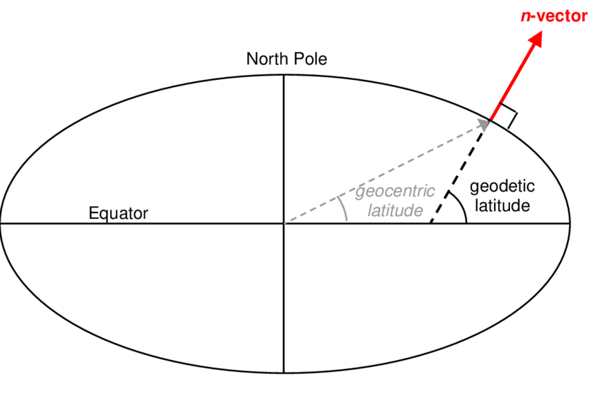
Geodetic uses a perpendicular line (normal) to the ellipsoidal surface; geocentric uses a straight line drawn to the Earth's center.
Note that logarithms transform divisions in subtractions:
- log(a/b) = log(a) - log(b)
- Δψ = toMercator(lat2, wgs) - toMercator(lat1, wgs)
Parameters:
| Name | Type | Default | Description |
|---|---|---|---|
lat1 |
Number | first latitude in degrees. | |
lat2 |
Number | second latitude in degrees. | |
wgs |
Boolean | false | whether to apply the wgs84 ellipsoidal model. |
Returns:
- Type
- Number
displayLocations()
Load new points on the GPU corresponding to the selected country.
Then, triggers the animation to update the canvas.- Source:
- See:
displayVersions(index)
Display GLSL and OpenGL versions, device pixel ratio, ppi and textimg length (cm) in the "options" element.
The standard css pixel length is 1/96 of an inch.Parameters:
| Name | Type | Description |
|---|---|---|
index |
Number | pixel density index. |
- Source:
- See:
dms2dd(degrees, minutes, seconds, hemisphere) → {Number}
Convert from degrees, minutes and seconds to decimal degrees.
Parameters:
| Name | Type | Description |
|---|---|---|
degrees |
Number | degrees. |
minutes |
Number | minutes. |
seconds |
Number | seconds. |
hemisphere |
String | ("S", "N", "E", "W"). |
- Source:
Returns:
- Type
- Number
draw()
- Source:
drawAxes()
Draws the axes.
Uses the colorShader.- Source:
drawLines()
Draws the lines: mesh + normals.
Uses the colorShader with colors defined in a colorTable.This code takes too long on mobile - too many API calls.
 // draw edges
 gl.bindBuffer(gl.ARRAY_BUFFER, vertexBuffer);
 gl.vertexAttribPointer(positionIndex, 3, gl.FLOAT, false, 0, 0);
 gl.bindBuffer(gl.ELEMENT_ARRAY_BUFFER, indexBuffer);
 for (let i = 0; i < theModel.indices.length; i += 3) {
     // offset - two bytes per index (UNSIGNED_SHORT)
     gl.drawElements(gl.LINE_LOOP, 3, gl.UNSIGNED_SHORT, i * 2);
 }
The solution is having a single buffer with all lines,
which was set in createModel.
- Source:
- See:
drawLinesOnImage(canvasimgopt) → {Number|null}
Draw the meridian and parallel lines at the currentLocation on the texture image, or the loxodrome and rhumb line if loxodrome is selected, plus the great circle projection.
The loxodrome is a straight line connecting the previous to the current location and its bearing angle is the angle it makes with the y-axis.Parameters:
| Name | Type | Attributes | Default | Description |
|---|---|---|---|---|
canvasimg |
HTMLCanvasElement |
<optional> |
element.canvasimg | the canvas element to draw on. |
- Source:
- See:
-
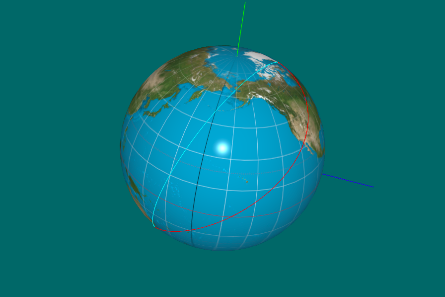
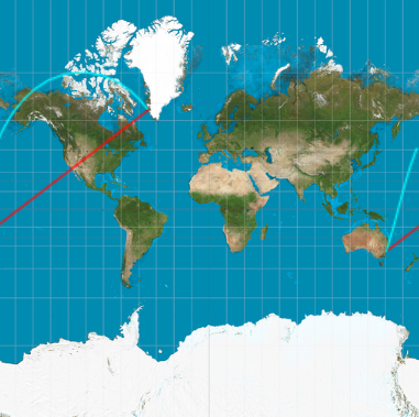
Rhumb Line (red) - Great Circle (cyan)
Sidney - Nuuk (16301 km, 52.53°)
Returns:
- Type
- Number | null
drawLocations()
Draws all location points on the globe.
Uses the colorShader.- Source:
drawLocationsOnImage(canvasimgopt)
Parameters:
| Name | Type | Attributes | Default | Description |
|---|---|---|---|---|
canvasimg |
HTMLCanvasElement |
<optional> |
element.canvasimg | the canvas element to draw on. |
- Source:
drawParallel()
- Source:
drawTexture()
Texture render the current model.
Uses the lightingShader.If the attribute "a_TexCoord" is not defined in the vertex shader, texture coordinates will be calculated pixel by pixel in the fragment shader.
We can also set a uniform attribute (u_mercator) in the shader, for using a Mercator projection instead of an equirectangular projection.
- Source:
equiLox(ctx, loc1, loc2, nopt) → {Number|null}
Draw the rhumb line (loxodrome is true), or the meridian and parallel lines otherwise, between two GCS locations on the texture image for the equirectangular cylindrical projection.
The loxodrome image will NOT be a straight line in the plane of the equidistant cylindrical projection, but another curve.Note: for a Mercator projection, please use rhumbLine.
Parameters:
| Name | Type | Attributes | Default | Description |
|---|---|---|---|---|
ctx |
CanvasRenderingContext2D | 2D rendering context of the canvas. | ||
loc1 |
gpsCoordinates | previous location. | ||
loc2 |
gpsCoordinates | current location. | ||
n |
Number |
<optional> |
20 | number of points to approximate the loxodrome. |
- Source:
- See:
-
- A New Derivation of the Formula for the Length of a Loxodrome Arc on a Sphere Using Cylindrical Projections
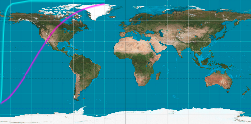
Loxodrome (magenta) is a sigmoid
(S-shaped curve) in the equirectangular projection
Returns:
- Type
- Number | null
fmtDistance(value, unit) → {String}
Parameters:
| Name | Type | Default | Description |
|---|---|---|---|
value |
Number | distance. | |
unit |
String | all | "km", "mi", "nm", "all" |
- Source:
Returns:
- Type
- String
fmtdeg(angle) → {String}
Object that enables language-sensitive number formatting.
The format() method of Intl.NumberFormat instances formats a number according to the locale and formatting options of this Intl.NumberFormat object.This instance formats an angle in degrees to a string with the appropriate unit.
Parameters:
| Name | Type | Description |
|---|---|---|
angle |
Number | in degrees. |
- Source:
- See:
Returns:
- Type
- String
fmtkm(distance) → {String}
Object that enables language-sensitive number formatting.
The format() method of Intl.NumberFormat instances formats a number according to the locale and formatting options of this Intl.NumberFormat object.This instance formats a distance in kilometers to a string with the appropriate unit.
Parameters:
| Name | Type | Description |
|---|---|---|
distance |
Number | in kilometers. |
- Source:
- See:
Returns:
- Type
- String
fmtmi(distance) → {Object}
Object that enables language-sensitive number formatting.
The format() method of Intl.NumberFormat instances formats a number according to the locale and formatting options of this Intl.NumberFormat object.This instance formats a distance in miles to a string with the appropriate unit.
Parameters:
| Name | Type | Description |
|---|---|---|
distance |
Number | in miles. |
- Source:
- See:
Returns:
- Type
- Object
fmtnm(distance) → {Object}
Object that enables language-sensitive number formatting.
The format() method of Intl.NumberFormat instances formats a number according to the locale and formatting options of this Intl.NumberFormat object.This instance formats a distance in miles to a string with the appropriate unit.
Parameters:
| Name | Type | Description |
|---|---|---|
distance |
Number | in nautical miles. |
- Source:
- See:
Returns:
- Type
- Object
formatNumberWithSign(num, decimals) → {String}
Parameters:
| Name | Type | Description |
|---|---|---|
num |
Number | number. |
decimals |
Number | number of digits to appear after the decimal point. |
- Source:
Returns:
- Type
- String
gcs2Screen(location, mercatorProjectionopt) → {Object}
Convert from GCS (longitude, latitude) to screen coordinates.
This function uses the WebGL projection to convert the geographic coordinates to screen coordinates (pixels).- The projection can be either cylindrical, conical, spherical or Mercator.
- The spherical projection is used for a globe, while the Mercator projection is used for a map.
Parameters:
| Name | Type | Attributes | Default | Description |
|---|---|---|---|---|
location |
GCS | gcs coordinates. | ||
mercatorProjection |
Boolean |
<optional> |
false | whether to use Mercator projection. |
Properties:
| Name | Type | Description |
|---|---|---|
Coordinates.screen |
Array.<{x:Number, y:Number}> | screen coordinates. |
Coordinates.cartesian |
vec3 | cartesian coordinates. |
Coordinates.uv |
Object.<{s:Number, t:Number}> | spherical coordinates in UV space. |
Coordinates.viewport |
Array.<Number> | viewport dimensions. |
- Source:
Returns:
- Type
- Object
gcs2UV(gcs) → {Object.<{s: Number, t: Number}>}
Parameters:
| Name | Type | Description |
|---|---|---|
gcs |
GCS | longitude ∈ [-180°,180°], latitude ∈ [-90°,90°]. |
- Source:
Returns:
- Type
- Object.<{s: Number, t: Number}>
gcsForUnknownLocation(uv) → {gpsCoordinates}
Parameters:
| Name | Type | Description |
|---|---|---|
uv |
Object.<{s: Number, t:Number}> | uv coordinates ∈ [0,1]. |
- Source:
Returns:
- Type
- gpsCoordinates
getAngleBetweenVectors(v1, v2) → {Number}
Calculate the angle in radians between two vectors.
- θ = atan2(||v1 × v2||, v1 • v2)) or
- θ = acos((v1 • v2) / (||v1|| ||v2||))
   const dotProduct = clamp(vec3.dot(v1, v2), -1, 1)/(vec3.length(v1)*vec3.length(v2));
   const angleInRadians = Math.acos(dotProduct);
Parameters:
| Name | Type | Description |
|---|---|---|
v1 |
vec3 | first vector. |
v2 |
vec3 | second vector. |
- Source:
- See:
Returns:
- Type
- Number
getAzimuthAndLoxodromeDistance(lat1, lon1, lat2, lon2) → {Object.<{bearing: Number, loxdist: Number, mp1: Number, mp2: Number}>}
Returns the azimuth and loxodromic distance between two GCS coordinates, by calculating their meridional parts found in navigation tables such as Bowditch's practical navigator and Norie's tables.
Azimuth is the clockwise angle between the north direction and the line connecting the two points and loxodromic distance is their distance along a loxodrome (rhumb line).
Since the calculation of the loxodromic distance relies on the difference of meridional parts, which is expressed in nautical miles, there is no need to pass the radius of the globe as a parameter to calculate it.Parameters:
| Name | Type | Description |
|---|---|---|
lat1 |
Number | latitude of the first point in degrees. |
lon1 |
Number | longitude of the first point in degrees. |
lat2 |
Number | latitude of the second point in degrees. |
lon2 |
Number | longitude of the second point in degrees. |
- Source:
- See:
Returns:
loxodromic distance in kilometers between (lat1, lon1) and (lat2, lon2) and
meridional parts mp1 and mp2.
- Type
- Object.<{bearing: Number, loxdist: Number, mp1: Number, mp2: Number}>
getChar(event) → {String|null}
Parameters:
| Name | Type | Description |
|---|---|---|
event |
KeyboardEvent | keyboard event. |
- Source:
- See:
Returns:
- Type
- String | null
getCitiesSelector() → {Array.<Number>}
- Source:
Returns:
- Type
- Array.<Number>
getConeParameters() → {Object.<r:Number, height:Number>}
Get cone parameters for plotting the current location on the cone.
- Source:
Returns:
- Type
- Object.<r:Number, height:Number>
getCylinderParameters(mercopt) → {Object.<r:Number, height:Number>}
Get cylinder parameters for plotting the current location on the cylinder.
Parameters:
| Name | Type | Attributes | Default | Description |
|---|---|---|---|---|
merc |
Boolean |
<optional> |
mercator | whether to use Mercator projection. |
- Source:
Returns:
- Type
- Object.<r:Number, height:Number>
getDate(v) → {Array.<Number>}
Return a location historical figure's last date mentioned and timeline.
In case it is a range of dates (first-second), it returns the first date.
I would like to return Date.parse(date). However, it does not work with BC dates (negative years).
Parameters:
| Name | Type | Description |
|---|---|---|
v |
String | location name. |
- Source:
- See:
Throws:
-
invalid or missing location date.
- Type
- RangeError
Returns:
- Type
- Array.<Number>
getDevicePixelRatio() → {Number}
Returns:
- Type
- Number
getIOSVersion() → {Number|null}
Returns the major IOS version (e.g., 16).
Note: returns 18 for IOS 26.- Source:
Returns:
- Type
- Number | null
getLongitude(v) → {Array.<Number>}
Return a location historical figure's longitude.
Parameters:
| Name | Type | Description |
|---|---|---|
v |
String | location name. |
- Source:
Returns:
- Type
- Array.<Number>
getModelData(geom) → {modelData}
Polyhedra have no index.
Parameters:
- Source:
Returns:
- Type
- modelData
getModelMatrix() → {mat4}
- Source:
Returns:
- Type
- mat4
getRealResolution(dpr) → {Object.<witdth:Number, height:Number>}
Parameters:
| Name | Type | Description |
|---|---|---|
dpr |
Number | device pixel ratio. |
- Source:
Returns:
- Type
- Object.<witdth:Number, height:Number>
getTextures(optionNames)
Parameters:
| Name | Type | Description |
|---|---|---|
optionNames |
Array.<String> | array of texture file names. |
- Source:
getWebGLContext(canvas, opt_debug) → {WebGL2RenderingContext}
Parameters:
| Name | Type | Description |
|---|---|---|
canvas |
HTMLCanvasElement | <canvas> element. |
opt_debug |
Boolean | flag to initialize the context for debugging. |
- Deprecated:
- since WebGL2
- Source:
- See:
Returns:
- Type
- WebGL2RenderingContext
handleDMS()
Handle input of GCS coordinates.
The effect is similar to clicking an unknown location.- Source:
handleKeyPress(event) → {key_event}
Closure for keydown events.
Chooses a model and which axis to rotate around.The subdivision level is limited for a chosen subdivision polyhedron.
When a new texture is selected, triggers callback image load event.
Parameters:
| Name | Type | Description |
|---|---|---|
event |
KeyboardEvent | keyboard event. |
- Source:
Returns:
- Type
- key_event
haversine(gcs1, gcs2, Ropt) → {Number}
Calculate distances on the globe using the Haversine Formula.
Haversine
formula:   a = sin²(Δφ/2) + cos φ1 ⋅ cos φ2 ⋅ sin²(Δλ/2)
           c = 2 ⋅ atan2( √a, √(1−a) )
           d = R ⋅ c

where:     φ is latitude, λ is longitude, R is earth’s radius (mean radius = 6,371km);
note:      angles need to be in radians to pass to trig functions!
Usage:
 const distance = haversine(
       gpsCoordinates["Alexandria"],
       gpsCoordinates["Aswan"],
 );
 console.log(`Distance: ${Math.round(distance.m, 3)} m`);
 console.log(`Distance: ${Math.round(distance.km, 3)} km`);

 >> Distance: 843754 m
 >> Distance: 844 km
Parameters:
| Name | Type | Attributes | Default | Description |
|---|---|---|---|---|
gcs1 |
GCS | first pair of gcs coordinates. | ||
gcs2 |
GCS | second pair of gcs coordinates. | ||
R |
Number |
<optional> |
earthRadius | radius of the globe in kilometers (default: 6371 km). |
- Source:
- See:
Returns:
- Type
- Number
initShaders(GL, vshader, fshader) → {Boolean}
Parameters:
| Name | Type | Description |
|---|---|---|
GL |
WebGLRenderingContext | context. |
vshader |
String | a vertex shader program. |
fshader |
String | a fragment shader program. |
- Source:
Returns:
- Type
- Boolean
isCardinalDirection(char) → {Boolean}
Parameters:
| Name | Type | Description |
|---|---|---|
char |
String | a character to check. |
- Source:
Returns:
- Type
- Boolean
isCone() → {Boolean}
- Source:
Returns:
- Type
- Boolean
isCylinder() → {Boolean}
- Source:
Returns:
- Type
- Boolean
isPowerOf2(value) → {Boolean}
Parameters:
| Name | Type | Description |
|---|---|---|
value |
Number | number to check. |
- Source:
Returns:
- Type
- Boolean
isSphere() → {Boolean}
- Source:
Returns:
- Type
- Boolean
isTouchDevice() → {Boolean}
Checks if the device is a touch device.
It checks for the presence of touch events in the window object and the maximum number of touch points supported by the device. This is useful for determining if the application should use touch-specific features or fall back to mouse events.- Source:
- See:
Returns:
- Type
- Boolean
isZero(a, epsilon) → {Boolean}
Parameters:
| Name | Type | Default | Description |
|---|---|---|---|
a |
Number | given number. | |
epsilon |
Number | 0.00001 | a sufficient small tolerance. |
- Source:
Returns:
- Type
- Boolean
knotsTokmh(a) → {Number}
Convert knots to kilometers per hour.
The knot is a unit of speed equal to one nautical mile per hour, exactly 1.852 km/hCaptains in the 1700s tossed ropes overboard with knots spaced out at 50 ft and used a sand glass that measured half of a minute to approximate the speed of a ship in nautical miles per hour.
- 50 ft / 0.5 min = 100 ft / 1 min × 1 nm / 6076 ft × 60 min / h = 0.9875 ≈ 1 nm / h
Parameters:
| Name | Type | Description |
|---|---|---|
a |
Number | speed in knots. |
- Source:
- See:
Returns:
- Type
- Number
labelForLocation(location, unit)
Updates the label (latitude, longitude, meridional parts and northing differences) to the information of the given location.
The label is updated in the element with attribute `for="equator"`:- sec(lat) is the secant of the latitude, which is the reciprocal of the cosine of the latitude.
- mp(lat) is the meridional part, which is the distance in minutes of longitude from the equator to a given latitude on a Mercator chart.
Parameters:
| Name | Type | Description |
|---|---|---|
location |
String | name of the location. |
unit |
String | "km", "mi", "nm", "all" |
- Source:
labelForTimeline(dat)
Parameters:
| Name | Type | Description |
|---|---|---|
dat |
Number | date. |
- Source:
lineConeIntersection(o, p, ct, r, height) → {vec3|null}
Find point of intersection between a line and a cone.
The line is defined by its origin and an end point. The cone is defined by its center, radius and height.Parameters:
| Name | Type | Description |
|---|---|---|
o |
vec3 | ray origin. |
p |
vec3 | ray end point. |
ct |
vec3 | center of the cone. |
r |
Number | radius of the cone. |
height |
Number | height of the cone. |
- Source:
- See:
Returns:
- Type
- vec3 | null
lineCylinderIntersection(o, p, ct, r, height) → {vec3|null}
Find point of intersection between a line and a cylinder.
The line is defined by its origin and an end point. The cylinder is defined by its center, radius and height.Parameters:
| Name | Type | Description |
|---|---|---|
o |
vec3 | ray origin. |
p |
vec3 | ray end point. |
ct |
vec3 | center of the cylinder. |
r |
Number | radius of the cylinder. |
height |
Number | height of the cylinder. |
- Source:
- See:
Returns:
- Type
- vec3 | null
linePlaneIntersection(o, p, pt, normal) → {vec3|null}
Find point of intersection between a line and a plane.
The line is defined by its origin and an end point. The plane is defined by a point on it and its normal vector.Parameters:
| Name | Type | Description |
|---|---|---|
o |
vec3 | ray origin. |
p |
vec3 | ray end point. |
pt |
vec3 | point defining the plane position. |
normal |
vec3 | plane normal. |
- Source:
- See:
Returns:
- Type
- vec3 | null
lineSphereIntersection(o, p, c, r) → {vec3|null}
Find point of intersection between a line and a sphere.
The line is defined by its origin and an end point. The sphere is defined by its center and radius.Parameters:
| Name | Type | Description |
|---|---|---|
o |
vec3 | ray origin. |
p |
vec3 | ray end point. |
c |
vec3 | center of the sphere. |
r |
Number | radius of the sphere. |
- Source:
- See:
Returns:
- Type
- vec3 | null
loadShader(gl, type, source) → {WebGLShader}
Parameters:
| Name | Type | Description |
|---|---|---|
gl |
WebGLRenderingContext | GL context. |
type |
gl.VERTEX_SHADER | gl.FRAGMENT_SHADER | the type of the shader object to be created, |
source |
DOMString | shader program. |
- Source:
- See:
Returns:
- Type
- WebGLShader
longitudeOnLoxodrome(lat0, long0, lat, bearing) → {Array.<Number, Number>}
Return the longitude on a loxodrome at latitude, lat, given the latitude, lat0, and longitude, long0, at the beginning of the line and its bearing angle.
A loxodrome is a curve that crosses all meridians at the same angle. On a Mercator projection, a loxodrome is a straight line, and this function uses this property to compute the longitude at the given latitude.Note: this function is identical to longitudeOnRhumbLine
Parameters:
| Name | Type | Description |
|---|---|---|
lat0 |
Number | gcs latitude of the starting point, in degrees. |
long0 |
Number | gcs longitude of the starting point, in degrees. |
lat |
Number | gcs latitude of the point to compute, in degrees. |
bearing |
Number | in degrees, with 0° being north and increasing clockwise. |
- Source:
- See:
Returns:
- Type
- Array.<Number, Number>
longitudeOnRhumbLine(lat0, long0, lat, bearing) → {Array.<Number, Number>}
Parametrization of a loxodrome.
Return the longitude on a rhumb line at latitude, lat, given the latitude, lat0, and longitude, long0, at the beginning of the line and its bearing angle.
A rhumb line is a curve that crosses all meridians at the same angle.- tg(90°-θ) = cotg(θ) = 1 / tg(θ) = Δλ / Δψ
- ℓα: (0,π) ⟶ 𝕊2
- Z up
- φ ↦ (r cos(θα(φ)) sin(φ), r sin(θα(φ)) sin(φ), r cos(φ))
- Y up (north pole)
- φ ↦ (r cos(θα(φ)) sin(φ), -r cos(φ), -r sin(θα(φ)) sin(φ))
- θα(φ) = θ₀ + tan (α) [ln (cot (φ/2)) − ln (cot (φ₀/2))]
Parameters:
| Name | Type | Description |
|---|---|---|
lat0 |
Number | gcs latitude of the starting point, in degrees. |
long0 |
Number | gcs longitude of the starting point, in degrees. |
lat |
Number | gcs latitude of the point to compute, in degrees. |
bearing |
Number | in degrees, with 0° being north and increasing clockwise. |
- Source:
- See:
Returns:
- Type
- Array.<Number, Number>
lowerBound(arr, target) → {Number}
Returns the index of the first element in a sorted array that is greater or equal to a given target in O(log(n)).
If all elements are smaller than the target, then returns the array's length.- lowerBound([2, 3, 7, 10, 11, 11, 25], 9) → 3
- lowerBound([2, 3, 7, 10, 11, 11, 25], 11) → 4
- lowerBound([2, 3, 7, 10, 11, 11, 25], 100) → 7
Parameters:
| Name | Type | Description |
|---|---|---|
arr |
Array | the sorted array to search. |
target |
String | Number | the value to search for. |
- Source:
- See:
Returns:
- Type
- Number
lowerBoundLinear(arr, target) → {Number}
Returns the index of the first element in an array that is greater or equal to a given target in O(n).
If all elements are smaller than the target, then returns the array's length.Parameters:
| Name | Type | Description |
|---|---|---|
arr |
Array | the sorted array to search. |
target |
String | Number | the value to search for. |
- Source:
- See:
Returns:
- Type
- Number
loxodromeDestination(loc1, theta, d, Ropt) → {gpsCoordinates}
Formula:   φ2 = φ1 + δ ⋅ cos θ
           Δψ = ln( tan(π/4 + φ2/2) / tan(π/4 + φ1/2) )
           q = Δφ / Δψ (or cos φ for E-W line)
           Δλ = δ ⋅ sin θ / q
           λ2 = λ1 + Δλ

where:     δ is angular distance,
           θ is the bearing angle
           φ is geodetic latitude,
           ψ is isometric latitude,
           λ is longitude,
           Δλ is taking shortest route (<180°),
           ln is natural log, R is the earth’s radius

Doolittle Raid = loxodromeDestination(
   { latitude: 37.77493, longitude: -122.41942 },
     268.1, 7621,
   ) => { longitude: 152.20187347778597, latitude: 35.502563605922944 } =
        { longitude: 152° 12' 6.75" E, latitude: 35° 30' 9.23" N }

Dover - Calais = loxodromeDestination(
   { latitude: 51.12556, longitude: 1.33806 },
     116.64, 40.23,
   ) => { longitude: 1.8524241637667456, latitude: 50.96333626077345 } =
        { longitude: 1° 51' 8.71" E, latitude: 50° 57' 48.02" N }
Parameters:
| Name | Type | Attributes | Default | Description |
|---|---|---|---|---|
loc1 |
gpsCoordinates | starting location with latitude and longitude. | ||
theta |
Number | bearing angle. | ||
d |
Number | distance from loc1 in kilometers. | ||
R |
Number |
<optional> |
earthRadius | earth radius. |
- Source:
- See:
Returns:
- Type
- gpsCoordinates
makeNormalMatrixElements(model, view) → {mat3}
Matrix for taking normals into eye space.
Return a matrix to transform normals, so they stay perpendicular to surfaces after a linear transformation.Parameters:
| Name | Type | Description |
|---|---|---|
model |
mat4 | model matrix. |
view |
mat4 | view matrix. |
- Source:
- See:
Returns:
- Type
- mat3
meridianMatrix(out, meridian, increment) → {mat4}
Returns a rotation matrix around the vector perpendicular to the given meridian, by the given increment.
Ensure longitude is in [0,180) range, so that the perpendicular vector does not change direction if longitude is in the western hemisphere.Parameters:
| Name | Type | Description |
|---|---|---|
out |
mat4 | the receiving matrix. |
meridian |
GCS | given meridian. |
increment |
Number | angle (in radians) to rotate around. |
- Source:
Returns:
- Type
- mat4
meridianPerpVec(longitude) → {vec3}
Parameters:
| Name | Type | Description |
|---|---|---|
longitude |
Number | meridian longitude. |
- Source:
Returns:
- Type
- vec3
meridionalParts(lat) → {Number}
   const gps = gpsCoordinates[location];
   const uv = gcs2UV(gps);
   const merc = spherical2Mercator(uv.s, uv.t);
   const mp = (merc.y * 2 - 1) * 10800;
                       or
   const mp = toDegrees(toMercator(toRadian(lat))) * 60;
Parameters:
| Name | Type | Description |
|---|---|---|
lat |
Number | latitude in degrees. |
- Source:
- See:
Returns:
- Type
- Number
meta()
Whether the meta key (Command or ⌘ on macOS) has been held down.
- On macOS, the meta key is the Command key (⌘).
- On Windows and Linux, the meta key is the Control key (Ctrl).
- Source:
mod(n, m) → {Number}
Modulo operation that handles negative numbers correctly.
Always takes the sign of the divisor, i.e., the result is always non-negative if the divisor is positive,
Parameters:
| Name | Type | Description |
|---|---|---|
n |
Number | dividend. |
m |
Number | divisor. |
- Source:
Returns:
- Type
- Number
newTexture(image)
Creates a new texture from an image.
Uses the lightingShader.Parameters:
| Name | Type | Description |
|---|---|---|
image |
HTMLImageElement | texture. |
- Source:
- See:
nextLevel()
- Source:
nextLocation(inc, initialLocation, filter) → {Number}
Parameters:
| Name | Type | Description |
|---|---|---|
inc |
Number | increment (-1, 0 or 1). |
initialLocation |
Number | initial location index. |
filter |
String | set of locations to look for. |
- Source:
Returns:
- Type
- Number
nextTexture()
- Source:
nmTokm(a) → {Number}
Convert nautical miles to kilometers.
It is the length of one minute of latitude at the equator.- Earth's circumference: 2 * π * earthRadius Km = 40030.1736 km
- 40030 km / 360 / 60 = 1.8532407 km
Parameters:
| Name | Type | Description |
|---|---|---|
a |
Number | distance in nautical miles. |
- Source:
- See:
-
- toNauticalMiles for converting kilometers to nautical miles.
Returns:
- Type
- Number
northingDifference(city) → {Array.<Number>}
Return the northing and global differences at the given location between Mercator (EPSG:3395) and Pseudo-Mercator (EPSG:3857) projections.
Pseudo-Mercator is a projected coordinate system used for rendering maps in Google Maps, OpenStreetMap, etc.However, it is not a recognised geodetic system and uses spherical development of ellipsoidal coordinates. Relative to WGS 84 / World Mercator (CRS code 3395) gives errors of 0.7 percent in scale and differences in northing of up to 43km in the map (21km on the ground).
Parameters:
| Name | Type | Description |
|---|---|---|
city |
String | location. |
- Source:
- See:
Returns:
- Type
- Array.<Number>
parseDMS(input) → {Number}
Note that only the following characters get here:
-
for latitude:
- ' ° " . - SNsn 0-9
- ' ° " . - EWew 0-9
- ".34 abs 123 ns" → Array [ ".34", "s", "123", "ns" ]
Parameters:
| Name | Type | Description |
|---|---|---|
input |
String | DD or DMS string. |
- Source:
- See:
Returns:
- Type
- Number
pixelRayIntersection(x, y) → {vec3|null}
Parameters:
| Name | Type | Description |
|---|---|---|
x |
Number | pixel x coordinate. |
y |
Number | pixel y coordinate. |
- Source:
Returns:
- Type
- vec3 | null
playSongFromLink(url)
Parameters:
| Name | Type | Description |
|---|---|---|
url |
String | song url. |
- Source:
pointsOnAllLocations(locopt) → {Array.<Float32Array>}
Parameters:
| Name | Type | Attributes | Default | Description |
|---|---|---|---|---|
loc |
Array.<String> |
<optional> |
cities.current | locations array. |
Properties:
| Name | Type | Description |
|---|---|---|
0 |
Float32Array | locations coordinate array. |
1 |
Float32Array | locations color array. |
- Source:
- See:
Returns:
- Type
- Array.<Float32Array>
pointsOnConeMeridian(longitudeopt) → {Float32Array}
Parameters:
| Name | Type | Attributes | Default | Description |
|---|---|---|---|---|
longitude |
Number |
<optional> |
0 | distance east or west of the prime meridian: [-180°,180°] |
- Source:
Returns:
- Type
- Float32Array
pointsOnConeParallel(latitudeopt, nopt) → {Float32Array}
Parameters:
| Name | Type | Attributes | Default | Description |
|---|---|---|---|---|
latitude |
Number |
<optional> |
0 | distance north or south of the Equator: [-90°,90°]. |
n |
Number |
<optional> |
nsegments | number of points. |
- Source:
Returns:
- Type
- Float32Array
pointsOnCylMeridian(longitudeopt) → {Float32Array}
Parameters:
| Name | Type | Attributes | Default | Description |
|---|---|---|---|---|
longitude |
Number |
<optional> |
0 | distance east or west of the prime meridian: [-180°,180°] |
- Source:
Returns:
- Type
- Float32Array
pointsOnCylParallel(latitudeopt, nopt) → {Float32Array}
Parameters:
| Name | Type | Attributes | Default | Description |
|---|---|---|---|---|
latitude |
Number |
<optional> |
0 | distance north or south of the Equator: [-90°,90°]. |
n |
Number |
<optional> |
nsegments | number of points. |
- Source:
Returns:
- Type
- Float32Array
pointsOnGreatCircle(loc1, loc2, nsopt) → {Array.<Float32Array, Array>}
Return an array with ns points on an orthodrome (great circle) from loc1 to loc2.
The shortest path between two points on a sphere is the minor arc of the great circle passing through them, known as the geodesic. However, differently from a rhumb line, it is a curve when projected either onto an Equirectangular or Mercator map.- P(t) = C + R cos(t) u + R sin(t) v, t ∈ [0,θ]
- R = globeRadius
- C = (0, 0, 0)
Parameters:
| Name | Type | Attributes | Default | Description |
|---|---|---|---|---|
loc1 |
gpsCoordinates | first location with latitude and longitude. | ||
loc2 |
gpsCoordinates | second location with latitude and longitude. | ||
ns |
Number |
<optional> |
nsegments | number of points. |
Properties:
| Name | Type | Description |
|---|---|---|
0 |
Float32Array | points on the great circle. |
1 |
Float32Array | points in mercator coordinates. |
- Source:
- See:
-
- Great-circle navigation
- Great Circle
- A Novel Approach to Loxodrome (Rhumb Line), Orthodrome (Great Circle) and Geodesic Line in ECDIS and Navigation in General
- A Comparative Analysis of Rhumb Lines and Great Circles
- Circles and spheres
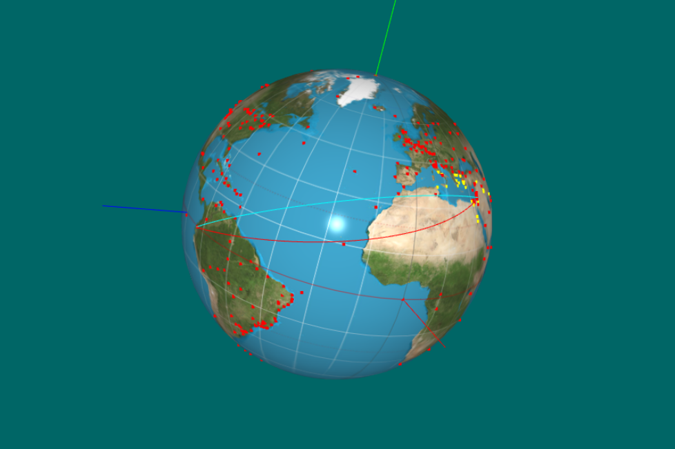
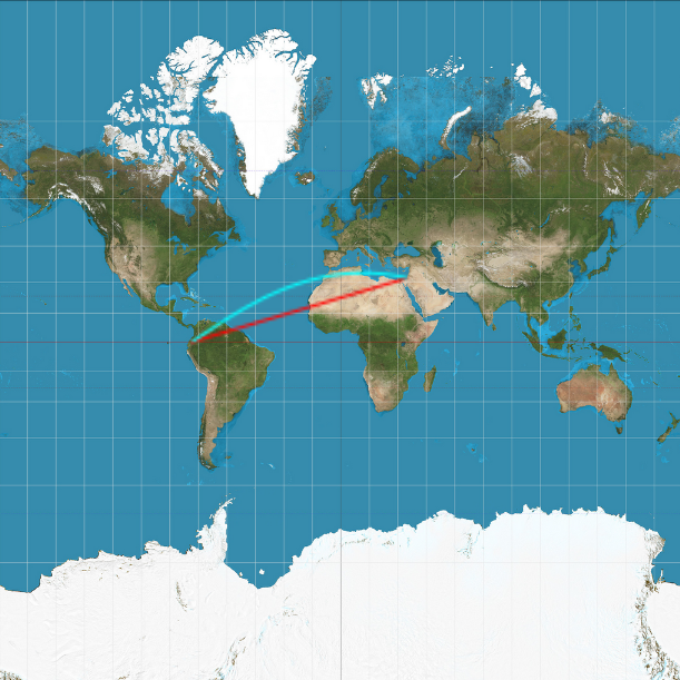
Great Circle (cyan) - Rhumb Line (red)
Quito - Jerusalem (12247 km, 73.47°)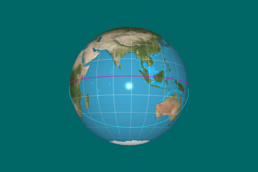
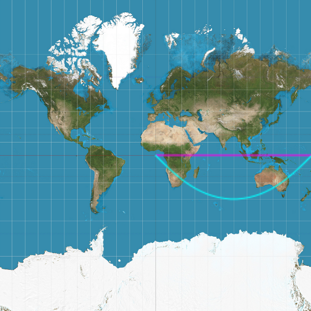
Great Circle (cyan) - Rhumb Line (magenta)
Null Island - Void Island (20015 km, 90°)
Returns:
- Type
- Array.<Float32Array, Array>
pointsOnLocations() → {Array.<Float32Array, Float32Array>}
Properties:
| Name | Type | Description |
|---|---|---|
0 |
Float32Array | locations coordinate array. |
1 |
Float32Array | locations color array. |
- Source:
- See:
Returns:
- Type
- Array.<Float32Array, Float32Array>
pointsOnLoxodrome(loc1, loc2, nopt) → {Float32Array}
Return an array with n points on a loxodrome (rhumb line) from loc1 to loc2, by using linear interpolation on the Mercator chart.
While a loxodrome is as a straight line on a Mercator projection, it is a non-linear, curved line on an Equirectangular projection.Loxodromic interpolation follows a path of constant bearing (azimuth) and it crosses all meridians at the same angle.
When crossing the antimeridian, the longitude difference (Δλ) must represent the shortest angular distance. A possible approach is using longitude values outside the [-180,180] range.- E.g., a line with two points with longitude values 170 and -150 (210) should cross the antimeridian when rendered, because it is the shortest distance.
A loxodrome on a cylinder is the shortest distance (geodesic) between two points. This is because a cylinder is a developable surface (has a Gaussian curvature of zero), which means it can be "unrolled" into a flat 2D plane without any distortion. On a standard vertical cylinder of radius 'r', this path is a circular helix, which has constant curvature and constant torsion.
Parameters:
| Name | Type | Attributes | Default | Description |
|---|---|---|---|---|
loc1 |
gpsCoordinates | first location with latitude and longitude. | ||
loc2 |
gpsCoordinates | second location with latitude and longitude. | ||
n |
Number |
<optional> |
nsegments | number of points. |
- Source:
- See:
-
- Rhumb line
- A Comparative Analysis of Rhumb Lines and Great Circles
- Gaussian curvature
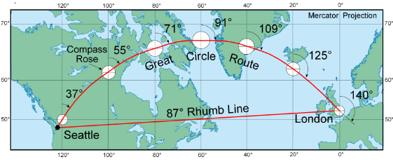
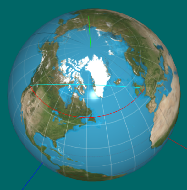
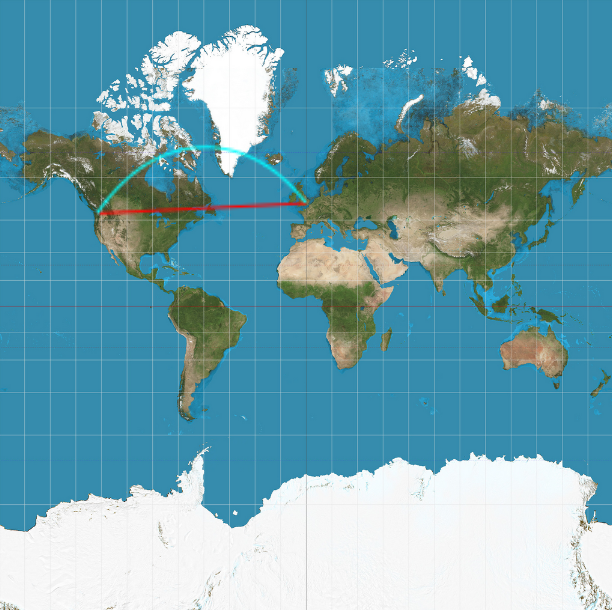
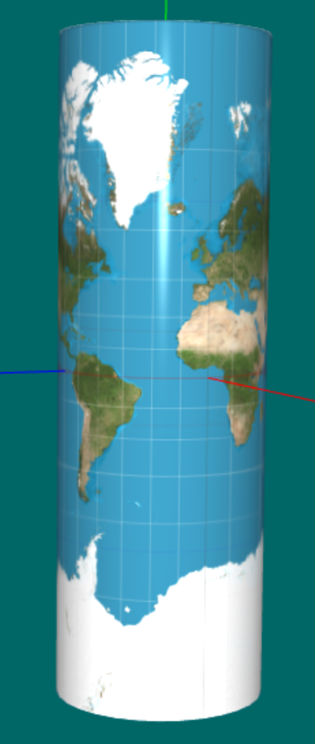
Seattle - London (7707 km, 87.21°) .png)
Antimeridian crossing fixed
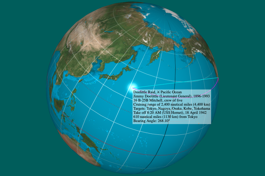
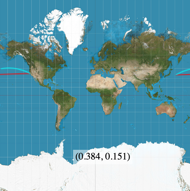
San Francisco - Doolittle Raid (7333 km, 268.10°)
Returns:
- Type
- Float32Array
pointsOnLoxodrome2(loc1, loc2, nopt) → {Float32Array}
Return an array with n points on a loxodrome (rhumb line) from loc1 to loc2 on a sphere, by using a parametrization of the loxodrome.
The loxodrome path is calculated in 3D onto the sphere, and not using the planar chart. Therefore, the correct curve will be traced even for an equirectangular cylindrical projection, as opposed to pointsOnLoxodrome, which is faster but intended to Mercator projections.Parameters:
| Name | Type | Attributes | Default | Description |
|---|---|---|---|---|
loc1 |
gpsCoordinates | first location with latitude and longitude. | ||
loc2 |
gpsCoordinates | second location with latitude and longitude. | ||
n |
Number |
<optional> |
nsegments | number of points. |
- Source:
- See:
-
- Parametrization of the loxodrome
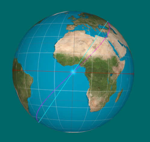
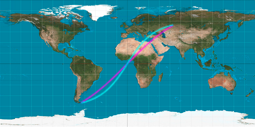
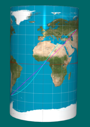
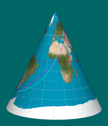
Cape Horn - Kurgan (17150 km, 44.51°)
Returns:
- Type
- Float32Array
pointsOnLoxodrome3(loc1, angle, dist) → {Float32Array}
Calculate the cartesian coordinates of points on a loxodrome (rhumb line) given a starting point, an angle and distance.
Parameters:
| Name | Type | Description |
|---|---|---|
loc1 |
gpsCoordinates | starting point. |
angle |
Number | bearing angle. |
dist |
Number | distance from loc1 in kilometers. |
- Source:
Returns:
- Type
- Float32Array
previousLevel()
- Source:
previousTexture()
- Source:
project(out, vec, modelMatrix, viewMatrix, projectionMatrix, viewport) → {Array.<Number>}
Transforms object space coordinates into screen coordinates.
Parameters:
| Name | Type | Description |
|---|---|---|
out |
Array.<Number> | the receiving vector. |
vec |
vec3 | 3D vector of object coordinates. |
modelMatrix |
mat4 | model matrix. |
viewMatrix |
mat4 | view matrix. |
projectionMatrix |
mat4 | projection matrix. |
viewport |
Array.<Number> | the current viewport (as from a gl.getParameter call). |
Returns:
- Type
- Array.<Number>
rhumbLine(ctx, loc1, loc2) → {Number|null}
Draw the rhumb line (loxodrome is true), or the meridian and parallel lines otherwise, between two GCS locations on the texture image for the Mercator projection.
The loxodrome image is a straight line in the projection plane.Note: for an equirectangular cylindrical projection, please use equiLox.
Parameters:
| Name | Type | Description |
|---|---|---|
ctx |
CanvasRenderingContext2D | 2D rendering context of the canvas. |
loc1 |
gpsCoordinates | previous location. |
loc2 |
gpsCoordinates | current location. |
- Source:
- See:
-
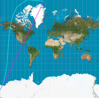
Loxodrome (magenta) is a
straight line
Returns:
- Type
- Number | null
ring(innerRadius, outerRadius, slices) → {modelData}
Creates a model of an annulus or disk lying in the xy plane, centered at the origin.
This is not a great representation, since all the normals are the same.Parameters:
| Name | Type | Description |
|---|---|---|
innerRadius |
Number | the radius of the hole in the radius; a value of
zero will give a disk rather than a ring. If ommited, the default value is 0.25. |
outerRadius |
Number | the radius of the ring, from the center to the
outer edge. Must be greater than innerRadius. If ommited, the default value is 2*innerRadius if innerRadius > 0 or 0.5 otherwise. |
slices |
Number | the number of radial subdivisions in the circular approximation of an annulus, minimum 3, default 32. |
- Source:
Returns:
- Type
- modelData
rotateGlobeAroundAxis(out, angle, axis) → {mat4}
Parameters:
| Name | Type | Description |
|---|---|---|
out |
mat4 | the receiving matrix. |
angle |
Number | angle in radians. |
axis |
vec3 | rotation axis. |
- Source:
Returns:
- Type
- mat4
rotateModelTowardsCamera(out, modelPosition, modelForward) → {mat4}
Rotate the model towards a given (forward) vector.
This function returns a rotation matrix to align the model's position with the given forward vector. The globe will rotate around the axis perpendicular to both the model's position and the forward vector, and the angle between them determines the rotation amount.
As a consequence, the globe's north vector (0,1,0) in the intrinsic frame can be rotated so that the 'earth' looks upside down. However, the fix is simple and requires an additional rotation around the modelForward vector by calling setYUp to keep the standard orientation convention: Europe up and South America down.Parameters:
| Name | Type | Description |
|---|---|---|
out |
mat4 | the receiving matrix. |
modelPosition |
vec3 | a model's vector in world coordinates. |
modelForward |
vec3 | model's forward vector in world coordinates. |
- Source:
Returns:
- Type
- mat4
saveLocations(filename)
Creates a JSON file with the GPS coordinates of the cities sorted by date or longitude.
The JSON file will have the following format:
 {
   "Thermopylae": {
   "country": "Greece",
   "remarkable": [
      "Battle of Thermopylae, 8 September 480 BC"
   ],
   "latitude": 38.7999968,
   "longitude": 22.5333312
 },
 ...
Parameters:
| Name | Type | Description |
|---|---|---|
filename |
String | name of the JSON file to be created. |
- Source:
- See:
saveWebGLCanvasAsPNG(blob, filename)
Saves the current WebGL canvas content as a PNG image.
Ensure preserveDrawingBuffer is true if needed for capturing post-render content:- const gl = canvas.getContext('theCanvas', { preserveDrawingBuffer: true });
Parameters:
| Name | Type | Description |
|---|---|---|
blob |
Blob | image blob. |
filename |
String | name of the file to save. |
scalarTripleProduct(a, b, c) → {Number}
Scalar triple product of three vectors.
The absolute value of the scalar triple product represents the volume of the parallelepiped formed by the three vectors a, b, and c when originating from the same point.The sign of the result indicates the orientation of the vectors (whether they form a right-handed or left-handed system). If the scalar triple product is zero, it means the three vectors are coplanar (lie in the same plane).
Parameters:
| Name | Type | Description |
|---|---|---|
a |
vec3 | first vector. |
b |
vec3 | second vector. |
c |
vec3 | third vector. |
- Source:
- See:
Returns:
- Type
- Number
searchByAnything(c, str) → {Boolean}
Parameters:
| Name | Type | Description |
|---|---|---|
c |
String | city name. |
str |
String | search string. |
- Source:
Returns:
- Type
- Boolean
searchByCity(c, str) → {Boolean}
Checks if a city name contains the search string.
Parameters:
| Name | Type | Description |
|---|---|---|
c |
String | city name. |
str |
String | search string. |
- Source:
Returns:
- Type
- Boolean
searchByCountry(c, str) → {Boolean}
Parameters:
| Name | Type | Description |
|---|---|---|
c |
String | city name. |
str |
String | search string. |
- Source:
Returns:
- Type
- Boolean
searchByRemarkable(c, str) → {Boolean}
Parameters:
| Name | Type | Description |
|---|---|---|
c |
String | city name. |
str |
String | search string. |
- Source:
Returns:
- Type
- Boolean
selectModel()
- Source:
- See:
selectTexture(getCnt)
Closure for selecting a texture from the menu.
Tetrahedra and octahedra may need to be reloaded for getting appropriate texture coordinates:- mercator x equirectangular.
Parameters:
| Name | Type | Description |
|---|---|---|
getCnt |
Boolean | indicates the need of getting textureCnt from <select> element in html. |
- Source:
setCanvasSize()
- Source:
setColor(elem1, elem2)
Parameters:
| Name | Type | Description |
|---|---|---|
elem1 |
HTMLInputElement | first element. |
elem2 |
HTMLInputElement | second element. |
- Source:
setCountryDescription(country) → {String}
Parameters:
| Name | Type | Description |
|---|---|---|
country |
String | name of the country. |
- Source:
Returns:
- Type
- String
setNorth(vertices, normals)
Rotate the given model so the y-axis points North.
The variable yNorth must be true, otherwise this function has no effect:- if (yNorth) (x, y, z) → (-x, z , y)
Parameters:
| Name | Type | Description |
|---|---|---|
vertices |
Float32Array | vertex array. |
normals |
Float32Array | normal array. |
- Source:
setPosition(location)
Load a new parallel and meridian, or a great circle and loxodrome, into the GPU corresponding to the given location.
In the case that a loxodrome is selected, the previous location is used as the starting point.Parameters:
| Name | Type | Description |
|---|---|---|
location |
String | a city name. |
- Source:
- See:
setRangeTicks(optionNames)
Parameters:
| Name | Type | Description |
|---|---|---|
optionNames |
Array.<Number> | array of timeline dates. |
- Source:
setRangeTicks2(optionNames)
Parameters:
| Name | Type | Description |
|---|---|---|
optionNames |
Array.<Number> | array of timeline dates. |
- Source:
setTextures(optionNames)
Parameters:
| Name | Type | Description |
|---|---|---|
optionNames |
Array.<String> | array of texture file names. |
- Source:
setUVfix() → {UVfix}
A closure holding the type of the model.
Tarini's method does not work for objects like polyhedra.It was meant for objects whose texture coordinates were set by using cylindrical or spherical uv-mappings.
For instance, a cube's face texture coordinates span from 0 to 1.
Therefore, we only use it for subdivision spheres.
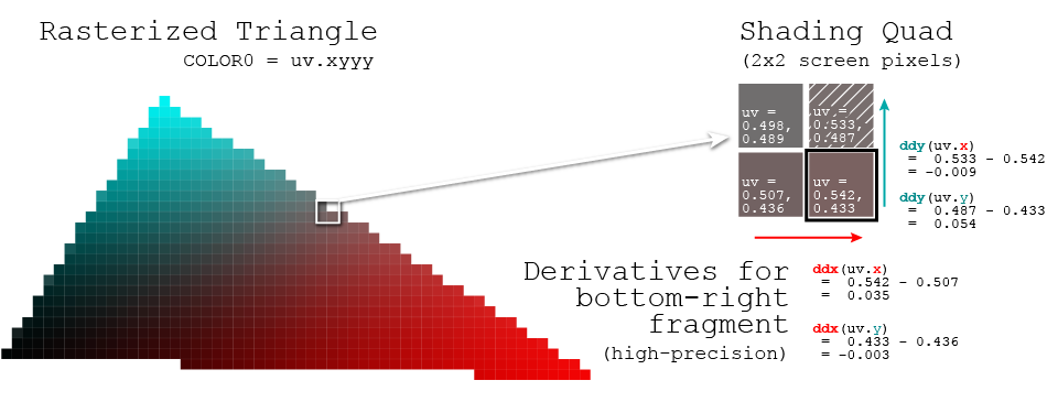
Returns:
- Type
- UVfix
setYUp(out, rotationMatrix, rotationAxis) → {mat4}
This function rotates the model around a given rotation axis (forward vector) after applying a given rotation matrix so its north vector (0,1,0) aligns with the screen y-axis (up vector).
The rotation prevents the globe from looking upside down by keeping the standard orientation convention: Europe up and South America down.
Because the coordinate system is intrinsic, the up vector is calculated by applying the inverse of the rotation matrix to the north vector.
Parameters:
| Name | Type | Description |
|---|---|---|
out |
mat4 | the receiving matrix. |
rotationMatrix |
mat4 | transformation matrix applied to model. |
rotationAxis |
vec3 | rotation axis. |
- Source:
- See:
Returns:
- Type
- mat4
sortCities(dataopt)
Sort an array of gpsCoordinates by date and longitude.
The sorted arrays are stored in the cities object, which has the following properties:- byDate: an array of city names sorted by date.
- byLongitude: an array of city names sorted by longitude.
- timeline: an array of dates corresponding to the cities in byDate.
- longitude: an array of longitudes corresponding to the cities in byLongitude.
- nameToDate: a mapping from city names to their corresponding dates.
- nameToLongitude: a mapping from city names to their corresponding longitudes.
Parameters:
| Name | Type | Attributes | Default | Description |
|---|---|---|---|---|
data |
Array.<gpsCoordinates> |
<optional> |
cities.byLongitude | array of gpsCoordinates objects. |
sortCitiesByDate(dataopt) → {Array.<Array>}
Return cities ordered by date and the timeline.
- location
- Array(463) [ "Null Island", "Memphis", "Giza", "Luxor", "Thebes", "Aswan", "Troy", "Ionia (İzmir)", "Babylon", "Miletus", … ]
- timeline
- Array(463) [ -9007199254740991, -2670, -2613, -2051, -1400, -1279, -1183, -850, -605, -585, … ]
- timemap
- Object { "Null Island": -9007199254740991, "Memphis": -2670, "Giza": -2613, "Luxor": -2051, "Thebes": -1400, "Aswan": -1279, "Troy": -1183, "Ionia (İzmir)": -850, "Babylon": -605, "Miletus": -585, … }
Parameters:
| Name | Type | Attributes | Default | Description |
|---|---|---|---|---|
data |
Array.<gpsCoordinates> |
<optional> |
cities.byLongitude | array of gpsCoordinates objects. |
Properties:
| Name | Type | Description |
|---|---|---|
0 |
Array.<String> | sort-value.location - list of names ordered by date. |
1 |
Array.<Number> | sort-value.timeline - list of corresponding years. |
2 |
Object.<{String, Number}> | sort-value.map - map associating city names to dates. |
- Source:
- See:
Returns:
- Type
- Array.<Array>
sortCitiesByLongitude(dataopt) → {Array.<Array>}
Parameters:
| Name | Type | Attributes | Default | Description |
|---|---|---|---|---|
data |
Array.<String> |
<optional> |
cities.byLongitude | array of gpsCoordinates objects. |
Properties:
| Name | Type | Description |
|---|---|---|
0 |
Array.<String> | sort-value.location - list of names ordered by longitude. |
1 |
Array.<Number> | sort-value.longitude - list of corresponding longitudes. |
2 |
Object.<{String, Number}> | sort-value.map - map associating city names to longitudes. |
- Source:
- See:
Returns:
- Type
- Array.<Array>
spherical2gcs(uv) → {Object.<{longitude: Number, latitude: Number}>}
Parameters:
| Name | Type | Description |
|---|---|---|
uv |
Object.<{s:Number, t:Number}> | spherical coordinates ∈ [0,1]}. |
- Source:
Returns:
- Type
- Object.<{longitude: Number, latitude: Number}>
startAnimation(delayopt) → {Number}
Parameters:
| Name | Type | Attributes | Default | Description |
|---|---|---|---|---|
delay |
Number |
<optional> |
4000 | The interval time in milliseconds. Defaults to 4000 milliseconds (4 seconds). This function will repeatedly call handleKeyPress with a simulated event that has the key 'g' pressed, effectively simulating a key press every delay ms. |
Returns:
- Type
- Number
startForReal(image)
Creates a textured model, sets the canvas size and triggers the animation.
Basically this function does setup that "should" only have to be done once,while draw() does things that have to be repeated each time the canvas is redrawn.
Parameters:
| Name | Type | Description |
|---|---|---|
image |
HTMLImageElement | texture. |
- Source:
- See:
toBlob(canvas) → {Promise.<Blob>}
Converts the content of a canvas to a Blob object.
This is useful for saving the canvas content as an image file.Parameters:
| Name | Type | Description |
|---|---|---|
canvas |
HTMLCanvasElement | the canvas element to convert. |
- Source:
- See:
Returns:
- Type
- Promise.<Blob>
toDegrees(a) → {Number}
Parameters:
| Name | Type | Description |
|---|---|---|
a |
Number | angle in radians. |
- Source:
Returns:
- Type
- Number
toMercator(lat, wgs) → {Number}
Convert latitude in radians to Mercator latitude.
Latitude is clamped to the range of [-maxLatitude, maxLatitude] to avoid singularities at the poles.- φ = lat, -π/2 ≤ φ ≤ π/2
- y = ln [tan (π/4 + φ/2)], -π ≤ y ≤ π or
- e = 0.0818191908426, eccentricity of the WGS 84 reference ellipsoid
- y = ln [tan (π/4 + φ/2) * ((1 − e * sin(φ)) / (1 + e * sin(φ))) e/2], -π ≤ y ≤ π
Parameters:
| Name | Type | Default | Description |
|---|---|---|---|
lat |
Number | latitude in radians ∈ [-π/2, π/2]. | |
wgs |
Boolean | false | whether to apply the wgs84 ellipsoidal model. |
- Source:
- See:
-
- spherical2Mercator
- How WGS 84 defines the Earth
- Web Mercator and Raster Tile Maps
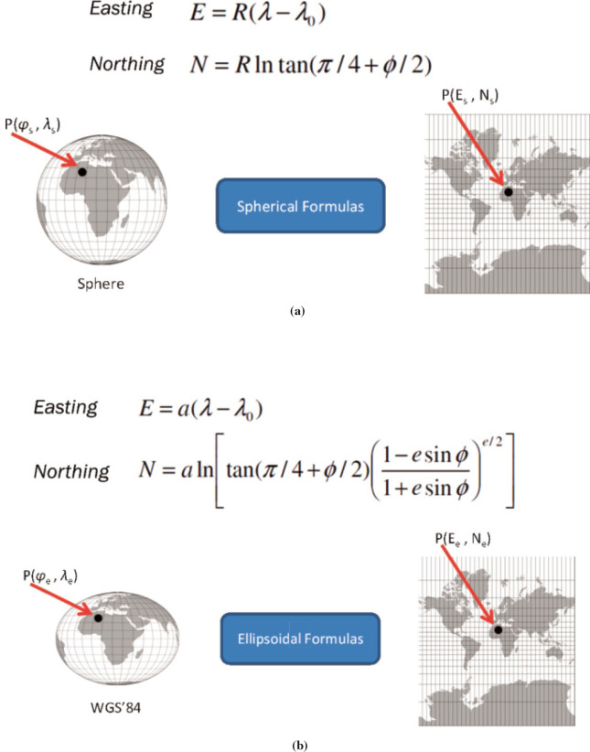
Spherical X Ellipsoidal
Returns:
- Type
- Number
toMiles(a) → {Number}
Parameters:
| Name | Type | Description |
|---|---|---|
a |
Number | distance in kilometers. |
- Source:
Returns:
- Type
- Number
toNauticalMiles(a) → {Number}
Convert kilometers to nautical miles.
A nautical mile is a unit of measurement used in maritime and aviation contexts, defined as exactly 1.852 kilometers (or approximately 1.15078 miles). It is the length of one minute of latitude at the equator.
- While one minute of latitude is consistently 1 NM, one minute of longitude only equals 1 NM at the equator.
- As you move toward the poles, the distance between longitude lines decreases.
- The International Hydrographic Organization adopted the "International Nautical Mile" in 1929 at exactly: 1 NM = 1,852 m.
- Earth's circumference: 2 * π * earthRadius Km = 40030.1736 km
- 40030 km / 360 / 60 = 1.8532407 km
Parameters:
| Name | Type | Description |
|---|---|---|
a |
Number | distance in kilometers. |
- Source:
- See:
Returns:
- Type
- Number
toRadian(a) → {Number}
Parameters:
| Name | Type | Description |
|---|---|---|
a |
Number | angle in degrees. |
- Source:
- See:
Returns:
- Type
- Number
toScreen(long, lat) → {Array.<Number, Number>}
Parameters:
| Name | Type | Description |
|---|---|---|
long |
Number | longitude in radians. |
lat |
Number | latitude in radians. |
- Source:
Returns:
- Type
- Array.<Number, Number>
toSpherical(y) → {Number}
Convert Mercator latitude in radians to spherical latitude.
- y = lat, -π ≤ y ≤ π
- φ = 2 atan (exp (y)) - π/2, -85.051129° ≤ φ ≤ 85.051129°
Parameters:
| Name | Type | Description |
|---|---|---|
y |
Number | Mercator latitude in radians ∈ [-π, π]. |
- Source:
- See:
Returns:
- Type
- Number
unproject(out, vec, modelMatrix, viewMatrix, projectionMatrix, viewport) → {Array.<Number>}
Transforms screen coordinates into object space coordinates.
Parameters:
| Name | Type | Description |
|---|---|---|
out |
Array.<Number> | the receiving vector. |
vec |
vec3 | 3D vector of screen coordinates. |
modelMatrix |
mat4 | model matrix. |
viewMatrix |
mat4 | view matrix. |
projectionMatrix |
mat4 | projection matrix. |
viewport |
Array.<Number> | the current viewport (as from a gl.getParameter call). |
- Source:
- See:
Returns:
- Type
- Array.<Number>
updateCurrentMeridian(x, y, setCurrentMeridian)
Updates the current meridian based on the given pixel position.
It calculates the intersection of the pixel ray with the sphere and converts the intersection point to spherical coordinates. If the intersection exists, it updates the currentMeridian variable and displays the coordinates in the canvastip element.Note that there is no cursor position on touch devices.
Parameters:
| Name | Type | Default | Description |
|---|---|---|---|
x |
Number | pixel x coordinate. | |
y |
Number | pixel y coordinate. | |
setCurrentMeridian |
Boolean | true | if true, updates the currentMeridian variable. |
- Source:
- See:
updateLocation(inc, fixopt, prevopt)
Update the current and previous locations and set the position on the globe or map.
The previous location is updated only if it has not been set in the canvas or textimg listeners for pointer clicks.
Some models, (such as spheres and cylinders) with a texture that represents a map, are rotated towards the camera when the tooltip is on.Parameters:
| Name | Type | Attributes | Default | Description |
|---|---|---|---|---|
inc |
Number | increment to change the current location. | ||
fix |
Boolean |
<optional> |
true | whether to call setYUp. |
prev |
Boolean |
<optional> |
true | whether to update previousLocation. |
- Source:
uvCone(radius, height, slices, stacks, noBottom) → {modelData}
Defines a model of a cone.
The axis of the cone is the z-axis, and the center is at (0,0,0).Parameters:
| Name | Type | Description |
|---|---|---|
radius |
Number | the radius of the cone |
height |
Number | the height of the cone. The cone extends from -height/2 to height/2 along the z-axis, with the tip at (0,0,height/2). |
slices |
Number | the number of slices, like the slices of an orange, minimum 3, default 32. |
stacks |
Number | the number of stacks, like horizontal cuts of an orange, minimum 1, default 16. |
noBottom |
Boolean | if missing or false, the cone has a bottom; if set to true,
the cone does not have a bottom. The bottom is a disk at the wide end of the cone. |
- Source:
- See:
Returns:
- Type
- modelData
uvCylinder(radius, height, slices, stacks, noTop, noBottom) → {modelData}
Defines a model of a cylinder.
The axis of the cylinder is the z-axis, and the center is at (0,0,0).Parameters:
| Name | Type | Description |
|---|---|---|
radius |
Number | the radius of the cylinder |
height |
Number | the height of the cylinder. The cylinder extends from -height/2 to height/2 along the z-axis. |
slices |
Number | the number of slices, like the slices of an orange, minimum 3, default 32. |
stacks |
Number | the number of stacks, like horizontal cuts of an orange, minimum 1, default 16. |
noTop |
Boolean | if missing or false, the cylinder has a top; if set to true,
the cylinder does not have a top. The top is a disk at the positive end of the cylinder. |
noBottom |
Boolean | if missing or false, the cylinder has a bottom; if set to true,
the cylinder does not have a bottom. The bottom is a disk at the negative end of the cylinder. |
- Source:
- See:
Returns:
- Type
- modelData
uvSphere(radius, slices, stacks) → {modelData}
Create a model of a sphere.
The z-axis is the axis of the sphere with the north pole on the positive z-axis and the center at (0,0,0).The number of triangles is 2 * slices * stacks, e.g., 48 * 24 * 2 = 2304.
However, two rows and one column of vertices have been duplicated.
Without vertex duplication,
the number of triangles would be 48 * 23 * 2 = 2208.
In fact, this is topologically a cylinder whose vertices on the two borders
have the same coordinates of the sphere north/south poles, respectively:
- uvSphere(radius, slices, stack) ≍ uvCylinder(r, height, slices, stack, true, true)
Parameters:
| Name | Type | Description |
|---|---|---|
radius |
Number | the radius of the sphere, default 0.5 if not specified. |
slices |
Number | the number of lines of longitude, minimum 3, default 32 |
stacks |
Number | the number of lines of latitude plus 1, minimum 2, default 16. (This is the number of vertical slices, bounded by lines of latitude, the north pole and the south pole.) |
- Source:
- See:
Returns:
- Type
- modelData
uvSphereND(radius, slices, stacks) → {modelData}
Create a model of a sphere.
The z-axis is the axis of the sphere with the north pole on the positive z-axis and the center at (0,0,0).This version does not duplicate vertices on the seam, but it does require Tarini's method when texturing.
Parameters:
| Name | Type | Description |
|---|---|---|
radius |
Number | the radius of the sphere, default 0.5 if not specified. |
slices |
Number | the number of lines of longitude, minimum 3, default 32 |
stacks |
Number | the number of lines of latitude plus 1, minimum 2, default 16. (This is the number of vertical slices, bounded by lines of latitude, the north pole and the south pole.) |
- Source:
- See:
Returns:
- Type
- modelData
uvTorus(outerRadius, innerRadius, slices, stacks) → {modelData}
Create a model of a torus (surface of a doughnut).
The z-axis goes through the doughnut hole, and the center of the torus is at (0,0,0).Parameters:
| Name | Type | Description |
|---|---|---|
outerRadius |
Number | the distance from the center to the outside of the tube, 0.5 if not specified. |
innerRadius |
Number | the distance from the center to the inside of the tube, outerRadius/3 if not
specified. (This is the radius of the doughnut hole.) |
slices |
Number | the number of lines of longitude, minimum 3, default 32. These are slices parallel to the z-axis and go around the tube the short way (through the hole). |
stacks |
Number | the number of lines of latitude plus 1, minimum 2, default 16. These lines are perpendicular to the z-axis and go around the tube the long way (around the hole). |
- Source:
- See:
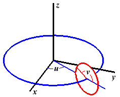
Returns:
- Type
- modelData
wgs84(lat) → {Number}
Calculates the ellipsoidal correction term for conformal mapping.
When flattening f = 0 (a perfect sphere), eccentricity e = 0. Raising any non-zero fraction to the power of 0 simplifies the entire expression to 1, reducing ellipsoidal equations back to their simpler spherical equivalents. For Earth models like WGS 84 where e ≈ 0.081819, this term slightly scales down the spherical radius to adjust for the equatorial bulge.Earth's equatorial diameter is about 43 km (27 mi) larger than its polar diameter, and Saturn has the largest bulge in our solar system,
Parameters:
| Name | Type | Description |
|---|---|---|
lat |
Number | geodetic latitude in radians. |
- Source:
- See:
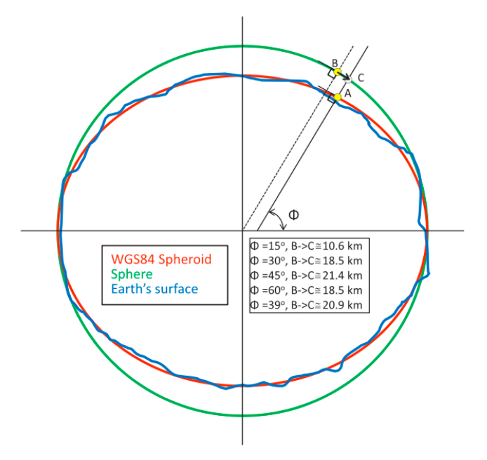
Returns:
- Type
- Number
wrapLatitude(latitude) → {Number}
Wrap latitude to the range [-90°, 90°).
Latitudes are typically expressed in the range of -90° to 90°, where positive values indicate north of the Equator and negative values indicate south.
Wrapping latitude is slightly more complex than wrapping longitude because, unlike longitude which repeats every 360°, latitude "bounces" or reverses direction at the poles (90°) and (-90°).Parameters:
| Name | Type | Description |
|---|---|---|
latitude |
Number | in degrees. |
- Source:
- See:
Returns:
- Type
- Number
wrapLongitude(longitude) → {Number}
Wrap longitude to the range [-180°, 180°).
Longitudes are typically expressed in the range of -180° to 180°, where positive values indicate east of the Prime Meridian and negative values indicate west.
Parameters:
| Name | Type | Description |
|---|---|---|
longitude |
Number | in degrees. |
- Source:
- See:
Returns:
- Type
- Number
zoomIn()
- Source:
zoomOut()
- Source:
Type Definitions
GCS
Properties:
| Name | Type | Description |
|---|---|---|
longitude |
Number | a geographic coordinate ∈ [-180°,180°] that specifies the east-west position of a point on Earth. |
latitude |
Number | a geographic coordinate ∈ [-90°,90°] that specifies a location's north-south position on Earth. |
- Source:
- See:
ImageLoadCallback()
Callback after a new texture image is loaded.
When called for the first time, it starts the animation. Otherwise, just loads a new texture.- Source:
UVfix(subModel)
Parameters:
| Name | Type | Description |
|---|---|---|
subModel |
Boolean | true: subdivision model, false: normal model, undefined: not known. Use the type saved in the closure. |
- Source:
frame()
- Source:
- See:
handleWindowResize(dopt)
Fires when the document view (window) has been resized.
Also resizes the canvas and viewport taking into account its aspect ratio.Parameters:
| Name | Type | Attributes | Default | Description |
|---|---|---|---|---|
d |
Boolean |
<optional> |
true | whether to redraw the scene. |
- Source:
- See:
key_event(event)
Handler for keydown events.
Parameters:
| Name | Type | Description |
|---|---|---|
event |
KeyboardEvent | keyboard event. |
- Source:
modelData
Polyhedra have no index.
Type:
- Object
Properties:
| Name | Type | Description |
|---|---|---|
vertexPositions |
Float32Array | vertex coordinates. |
vertexNormals |
Float32Array | vertex normals. |
vertexTextureCoords |
Float32Array | texture coordinates. |
indices |
Uint16Array | Uint32Array | index array. |
- Source:
Events
changeAxescheckBox
Executed when the axes checkbox is checked or unchecked.
Appends an event listener for events whose type attribute value is change.
The callback argument sets the callback that will be invoked when
the event is dispatched.
- Source:
- See:
changeCitiescheckBox
Executed when the cities checkbox is checked or unchecked.
Appends an event listener for events whose type attribute value is change.
The callback argument sets the callback that will be invoked when
the event is dispatched.
- Source:
- See:
changeCity
Executed when the city element is changed.
Appends an event listener for events whose type attribute value is change.
The callback argument sets the callback that will be invoked when
the event is dispatched.
- Source:
- See:
changeCountrySelect
Appends an event listener for events whose type attribute value is change.
The callback argument sets the callback that will be invoked when
the event is dispatched.
- Source:
- See:
changeCullcheckBox
Executed when the cull checkbox is checked or unchecked.
Appends an event listener for events whose type attribute value is change.
The callback argument sets the callback that will be invoked when
the event is dispatched.
- Source:
- See:
changeEquatorcheckBox
Executed when the equator checkbox is checked or unchecked.
Appends an event listener for events whose type attribute value is change.
The callback argument sets the callback that will be invoked when
the event is dispatched.
- Source:
- See:
changeFixUVcheckBox
Executed when the fix_uv checkbox is checked or unchecked.
Appends an event listener for events whose type attribute value is change.
The callback argument sets the callback that will be invoked when
the event is dispatched.
- Source:
- See:
changeHwscheckBox
Executed when the hws checkbox is checked or unchecked.
Appends an event listener for events whose type attribute value is change.
The callback argument sets the callback that will be invoked when
the event is dispatched.
- Source:
- See:
changeLatitudeValue
Appends an event listener for events whose type attribute value is change.
The callback argument sets the callback that will be invoked when
the event is dispatched.
- Source:
- See:
changeLocationscheckBox
Executed when the locations checkbox is checked or unchecked.
Appends an event listener for events whose type attribute value is change.
The callback argument sets the callback that will be invoked when
the event is dispatched.
- Source:
- See:
changeLongitudeValue
Appends an event listener for events whose type attribute value is change.
The callback argument sets the callback that will be invoked when
the event is dispatched.
- Source:
- See:
changeLoxodromecheckBox
Executed when the loxodrome checkbox is checked or unchecked.
Appends an event listener for events whose type attribute value is change.
The callback argument sets the callback that will be invoked when
the event is dispatched.
- Source:
- See:
changeMercatorcheckBox
Executed when the mercator checkbox is checked or unchecked.
Appends an event listener for events whose type attribute value is change.
The callback argument sets the callback that will be invoked when
the event is dispatched.
- Source:
- See:
changeMeshcheckBox
Executed when the mesh checkbox is checked or unchecked.
Appends an event listener for events whose type attribute value is change.
The callback argument sets the callback that will be invoked when
the event is dispatched.
- Source:
- See:
changeModeInputRadio
Executed when the mode input radio is checked (but not when unchecked).
Appends an event listener for events whose type attribute value is change.
The callback argument sets the callback that will be invoked when
the event is dispatched.
- Source:
- See:
changeModelsSelect
Appends an event listener for events whose type attribute value is change.
The callback argument sets the callback that will be invoked when
the event is dispatched.
- Source:
- See:
changeRotInputRadio
Executed when the rot input radio is checked (but not when unchecked).
Appends an event listener for events whose type attribute value is change.
The callback argument sets the callback that will be invoked when
the event is dispatched.
- Source:
- See:
changeScreenshot
Executed when the screenshot element is changed.
Appends an event listener for events whose type attribute value is change.
The callback argument sets the callback that will be invoked when
the event is dispatched.
- Source:
- See:
changeTextureSelect
Executed when the textures <select> is changed.
Appends an event listener for events whose type attribute value is change.
The callback argument sets the callback that will be invoked when
the event is dispatched.
- Source:
- See:
changeTexturecheckBox
Executed when the texture checkbox is checked or unchecked.
Appends an event listener for events whose type attribute value is change.
The callback argument sets the callback that will be invoked when
the event is dispatched.
- Source:
- See:
changeTooltipcheckBox
Executed when the tooltip checkbox is checked or unchecked.
Appends an event listener for events whose type attribute value is change.
The callback argument sets the callback that will be invoked when
the event is dispatched.
- Source:
- See:
changeUnitInputRadio
Executed when the unit input radio is checked (but not when unchecked).
Appends an event listener for events whose type attribute value is change.
The callback argument sets the callback that will be invoked when
the event is dispatched.
- Source:
- See:
clickAnimation
Executed when the animation element is clicked.
Appends an event listener for events whose type attribute value is click.
The callback argument sets the callback that will be invoked when
the event is dispatched.
- Source:
- See:
clickClosest
Executed when the closest element is clicked.
Appends an event listener for events whose type attribute value is click.
The callback argument sets the callback that will be invoked when
the event is dispatched.
- Source:
- See:
contextmenu
Parameters:
| Name | Type | Description |
|---|---|---|
event |
MouseEvent | mouse event. |
dblclick
Parameters:
| Name | Type | Description |
|---|---|---|
event |
MouseEvent | mouse event. |
keydown
Appends an event listener for events whose type attribute value is keydown.
The callback argument sets the callback that will be invoked when
the event is dispatched.
- Source:
- See:
keydownCountrySelect
Prevent country selection events whose type attribute value is keydown.
Appends an event listener for events whose type attribute value is keydown.
The callback
argument sets the callback that will be invoked when
the event is dispatched.
- Source:
- See:
keyup
Appends an event listener for events whose type attribute value is keyup.
The callback argument sets the callback that will be invoked when
the event is dispatched.
- Source:
- See:
latitudeClipboardEvent
Paste on latitude input.
The previous location is set only when both a new latitude and new longitude are entered. Otherwise, the longitude input field is drawn in "red", so the user is warned for entering a new longitude.Parameters:
| Name | Type | Description |
|---|---|---|
event |
ClipboardEvent | paste event. |
latitudeKeydown
Stop the event from "bubbling" up.
We want to ignore keys pressed inside this input.Parameters:
| Name | Type | Description |
|---|---|---|
event |
KeyboardEvent | keydown event. |
load
Loads the texture image and gpsCoordinates asynchronously and defines its load callback function.
Type:
- function
Parameters:
| Name | Type | Description |
|---|---|---|
event |
Event | load event. |
- Source:
- See:
longitudeClipboardEvent
Paste on longitude input.
The previous location is set only when both a new latitude and new longitude are entered. Otherwise, the latitude input field is drawn in "red", so the user is warned for entering a new latitude.Parameters:
| Name | Type | Description |
|---|---|---|
event |
ClipboardEvent | paste event. |
longitudeKeydown
Stop the event from "bubbling" up.
We want to ignore keys pressed inside this input.Parameters:
| Name | Type | Description |
|---|---|---|
event |
KeyboardEvent | keydown event. |
orientationchange
The orientationchange event is fired when the orientation of the device has changed.
This event is not cancelable and does not bubble.The orientationchange event fires immediately, causing a race condition where the browser's innerWidth and innerHeight values haven't updated to the new screen dimensions. Implementing a delay gives the device viewport time to stabilize.
- Deprecated:
- Listen for the change event of the ScreenOrientation interface instead.
- Source:
- See:
pointerdown-textimg
Gets the latitude and longitude on the texture image when clicked upon and draws its position on the map.
The pointerdown event is fired when a pointer becomes active. For mouse, it is fired when the device transitions from no buttons pressed to at least one button pressed. For touch, it is fired when physical contact is made with the digitizer. For pen, it is fired when the stylus makes physical contact with the digitizer.Parameters:
| Name | Type | Description |
|---|---|---|
event |
PointerEvent | a pointer event. |
- Source:
- See:
pointerdown-theCanvas
Sets moving to false and clicked to true.
The pointerdown event is fired when a pointer becomes active. For mouse, it is fired when the device transitions from no buttons pressed to at least one button pressed. For touch, it is fired when physical contact is made with the digitizer. For pen, it is fired when the stylus makes physical contact with the digitizer.This behavior is different from mousedown events. When using a physical mouse, mousedown events fire whenever any button on a mouse is pressed down. pointerdown events fire only upon the first button press; subsequent button presses don't fire pointerdown events.
Note: it is necessary to apply a delay of 50ms for IOS version beyond 17, so the pointerup event is also fired.
Parameters:
| Name | Type | Description |
|---|---|---|
event |
PointerEvent | a pointer event. |
pointermove-textimg
Displays the u and v normalized coordinates on the texture image when pointer is moved upon, or longitude and latitude if the Alt key is also held down while moving.
If the Control key is held down, displays the closest site instead.
The pointermove event is fired when a pointer changes coordinates, and the pointer has not been canceled by a browser touch-action. It's very similar to the mousemove event, but with more features.
These events happen whether or not any pointer buttons are pressed. They can fire at a very high rate, depends on how fast the user moves the pointer, how fast the machine is, what other tasks and processes are happening, etc.Parameters:
| Name | Type | Description |
|---|---|---|
event |
PointerEvent | a pointer event. |
- Source:
- See:
pointermove-theCanvas
Displays the GCS coordinates (longitude and latitude ) on the globe when pointer is moved upon or the closest site and distance if ctrl key is pressed while moving the pointer.
Sets moving to true if clicked is also true.
The pointermove event is fired when a pointer changes coordinates, and the pointer has not been canceled by a browser touch-action. It's very similar to the mousemove event, but with more features.
These events happen whether or not any pointer buttons are pressed. They can fire at a very high rate, depends on how fast the user moves the pointer, how fast the machine is, what other tasks and processes are happening, etc.Parameters:
| Name | Type | Description |
|---|---|---|
event |
PointerEvent | a pointer event. |
pointerout-textimg
Remove the tooltip when pointer is outside the textimg element.
The pointerout event is fired for several reasons including:- pointing device is moved out of the hit test boundaries of an element;
- firing the pointerup event for a device that does not support hover (see pointerup);
- after firing the pointercancel event (see pointercancel);
- when a pen stylus leaves the hover range detectable by the digitizer.
Parameters:
| Name | Type | Description |
|---|---|---|
event |
PointerEvent | a pointer event. |
- Source:
- See:
pointerup-theCanvas
Sets clicked to false and if moving is true, sets it to false and return, because we are moving the globe. Otherwise, gets the latitude and longitude on the globe and draws its position on the map.
The pointerup event is fired when a pointer is no longer active. This behavior is different from mouseup events. When using a physical mouse, mouseup events fire whenever any button on a mouse is released. pointerup events fire only upon the last button release; previous button releases, while other buttons are held down, don't fire pointerup events.Parameters:
| Name | Type | Description |
|---|---|---|
event |
PointerEvent | a pointer event. |
- Source:
- See:
resize
The resize event fires when the document view (window) has been resized.
The callback argument sets the callback that will be invoked when the event is dispatched.
- Source:
- See:
screenOrientationChange
Each time the orientation of the screen changes, the change event of the ScreenOrientation interface is triggered.
The callback argument sets the callback that will be invoked when the event is dispatched.
In landscape mode the browser toolbar and tabs reduce the viewport considerably.searchInput
The input event fires when the value of an <input>, <select>, or <textarea> element has been changed as a direct result of a user action (such as typing in a textbox or checking a checkbox).
Erases the select search element if the current value is completely empty.- Source:
- See:
searchKeydown
Handle search input for selecting cities.
The input is processed by a search predicate that filters the current set of cities. The effect is similar to clicking an unknown location.The keydown event is fired when a key is pressed.
The callback argument sets the callback that will be invoked when the event is dispatched.Parameters:
| Name | Type | Description |
|---|---|---|
event |
KeyboardEvent | keydown event. |
- Source:
- See:
timeline
Appends an event listener for events whose type attribute value is change.
Fired when a <input type="range"> is in the Range state (by clicking or using the keyboard).
The callback argument sets the callback that will be invoked when the event is dispatched. Executed when the slider is changed.Parameters:
| Name | Type | Description |
|---|---|---|
event |
Event | a generic event. |
- Source:
- See:
viewportResize
The resize event of the VisualViewport interface is fired when the visual viewport is resized. This allows you to position elements relative to the visual viewport as it is zoomed, which would normally be anchored to the layout viewport.
The callback argument sets the callback that will be invoked when the event is dispatched.
wheel
- Source: